Kumamap Kumamap Kumamap
Map Areas Trip Planner Sponsor Alerts Report
English 日本語 한국어 简体中文 繁體中文 ไทย
Sign in
Sign in
Map Areas Trip Planner Sponsor Alerts Report
English 日本語 한국어 简体中文 繁體中文 ไทย
  1. Home
  2. Kyoto
  3. Nantan
  4. Nantan Miyamacho-Sasari

Official Black Bear Nantan Miyamacho-Sasari, Kyoto Oct 19, 2024

0 views
Saw one too? Report it

Location

Description

No description provided

Bear Type

Black Bear

Number of Bears

1

Provider Type

Official

Date & Time

Saturday, October 19, 2024
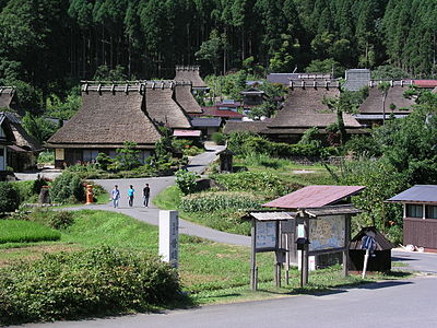
Address

Nantan Miyamacho-Sasari, Kyoto

Coordinates

35.276790, 135.698561

Sources

https://g-kyoto.gis.pref.kyoto.lg.jp/g-kyoto/ThemeSearch?mid...

Related Areas

Kyoto
Very High Risk

Kyoto

7,583 incidents

Kamo River
Moderate Risk

Kamo River

Kyoto

667 incidents

Katsura River
Moderate Risk

Katsura River

Kyoto

522 incidents

Takano River
Moderate Risk

Takano River

Kyoto

492 incidents

Nantan
Moderate Risk

Nantan

Kyoto

457 incidents

Sankoku take
Low Risk

Sankoku take

Kyoto

98 incidents

Kyoto
Very High Risk

Kyoto

7,583 incidents

Kamo River
Moderate Risk

Kamo River

Kyoto

667 incidents

Katsura River
Moderate Risk

Katsura River

Kyoto

522 incidents

Takano River
Moderate Risk

Takano River

Kyoto

492 incidents

Nantan
Moderate Risk

Nantan

Kyoto

457 incidents

Sankoku take
Low Risk

Sankoku take

Kyoto

98 incidents

Nearby places of interest

Shrine or Temple 606 m

Hachimanguu

八幡宮

Kyoto ·2 incidents

Community Centre 637 m

Sasari Kouminkan

佐々里公民館

Kyoto ·2 incidents

School 1.1 km

Shiritsu Kyouto Miyama Koutougakkou

私立京都美山高等学校

Kyoto ·2 incidents

Mountain 1.6 km

Hanano Tani Dan Yama

ハナノ谷段山

Kyoto ·29 incidents

Mountain 2.0 km

Oku Hatchou Yama

奥八丁山

Kyoto ·18 incidents

Waterfall 2.1 km

Nuno Taki

布滝

Kyoto ·2 incidents

Mountain 2.3 km

Daidan Taniyama

大段谷山

Kyoto ·14 incidents

Waterfall 2.9 km

Daidan Tani No Ootaki

大段谷の大滝

Kyoto ·10 incidents

Comments (0)

0/2000

No comments yet.

Plan Your Trip Risk Map

Hiking in bear country

Safety picks and trail essentials, top-rated on Amazon and Rakuten.

Nearby Incidents

Official

Nantan, Kyoto

437 m

1 year ago

Official

Nantan, Kyoto

2.2 km

1 year ago

Official

Nantan Miyamacho-Ashiu, Kyoto

3.0 km

1 year ago

Official

Nantan Miyamacho-Ashiu, Kyoto

3.0 km

1 year ago

Official

Nantan Miyamacho-Ashiu, Kyoto

3.0 km

1 year ago

Official

Nantan Miyamacho-Ashiu, Kyoto

3.6 km

2 years ago

Official

Nantan Miyamacho-Ashiu, Kyoto

3.7 km

1 year ago

Official

Nantan Miyamacho-Ashiu, Kyoto

3.8 km

1 year ago

Official

Nantan, Kyoto

437 m

1 year ago

Official

Nantan, Kyoto

2.2 km

1 year ago

Official

Nantan Miyamacho-Ashiu, Kyoto

3.0 km

1 year ago

Official

Nantan Miyamacho-Ashiu, Kyoto

3.0 km

1 year ago

Official

Nantan Miyamacho-Ashiu, Kyoto

3.0 km

1 year ago

Official

Nantan Miyamacho-Ashiu, Kyoto

3.6 km

2 years ago

Official

Nantan Miyamacho-Ashiu, Kyoto

3.7 km

1 year ago

Official

Nantan Miyamacho-Ashiu, Kyoto

3.8 km

1 year ago

Kumamap Kumamap

Track bear incidents across Japan. Stay safe outdoors.

Explore

Map Account Areas Places of Interest Predictions Near Me Trip Planner Trip Reports Community Alerts Gear

Learn

Bear Safety Guides Blog News Data FAQ

Mobile

iOS App Android App LINE WhatsApp

Company

About Contact Report Sponsor

Legal

Privacy Terms Commercial Disclosure
© 2026 Kumamap