Kumamap Kumamap Kumamap
Map Areas Trip Planner Sponsor Alerts Report
English 日本語 한국어 简体中文 繁體中文 ไทย
Sign in
Sign in
Map Areas Trip Planner Sponsor Alerts Report
English 日本語 한국어 简体中文 繁體中文 ไทย
  1. Home
  2. Niigata
  3. Uonuma
  4. Uonuma Yunotani-imogawa
Incident photo 1

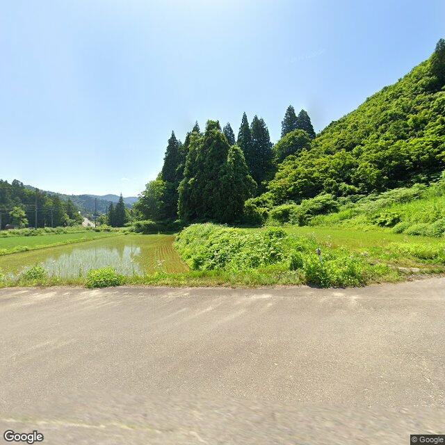
Official Black Bear Uonuma Yunotani-imogawa, Niigata Dec 19, 2025, 10:55 AM

0 views
Saw one too? Report it

Location

Description

Spotted one cub; afterward it moved into the mountains.

Note: Official sources provide information in Japanese only. This description has been machine translated for your convenience.

Bear Type

Black Bear

Number of Bears

1

Provider Type

Official

Date & Time

Friday, December 19, 2025 at 10:55 AM

Address

Uonuma Yunotani-imogawa, Niigata

Coordinates

37.211955, 139.044318

Sources

https://www.arcgis.com/apps/dashboards/20b4d06fb3b34776959a4...

Related Areas

Niigata
Very High Risk

Niigata

16,335 incidents

Echigo Sanzan-Tadami Quasi-National Park
Low Risk

Echigo Sanzan-Tadami Quasi-National Park

Niigata

1,844 incidents

Uonuma
Low Risk

Uonuma

Niigata

1,230 incidents

Mount Echigo-Komagatake
Low Risk

Mount Echigo-Komagatake

Niigata

482 incidents

Niigata
Very High Risk

Niigata

16,335 incidents

Echigo Sanzan-Tadami Quasi-National Park
Low Risk

Echigo Sanzan-Tadami Quasi-National Park

Niigata

1,844 incidents

Uonuma
Low Risk

Uonuma

Niigata

1,230 incidents

Mount Echigo-Komagatake
Low Risk

Mount Echigo-Komagatake

Niigata

482 incidents

Nearby places of interest

Mountain 3.6 km

Takara Rinsan

宝林山

Niigata ·455 incidents

Mountain 3.7 km

Gobyuu Yama

誤謬山

Niigata ·474 incidents

Mountain 4.4 km

Shiroyama

城山

Niigata ·540 incidents

Mountain 3.6 km

Takara Rinsan

宝林山

Niigata ·455 incidents

Mountain 3.7 km

Gobyuu Yama

誤謬山

Niigata ·474 incidents

Mountain 4.4 km

Shiroyama

城山

Niigata ·540 incidents

Comments (1)

0/2000

Lorelei NeutralLisa Wischofskyhttps://www.figma.com/community/file/1198749693280469639https://creativecommons.org/publicdomain/zero/1.0/Remix of „Lorelei Neutral” (https://www.figma.com/community/file/1198749693280469639) by „Lisa Wischofsky”, licensed under „CC0 1.0” (https://creativecommons.org/publicdomain/zero/1.0/)
Anna 6 months ago

Spotted right before the new year, that's when they're usually moving deeper anyway.

Plan Your Trip Risk Map

Hiking in bear country

Safety picks and trail essentials, top-rated on Amazon and Rakuten.

Nearby Incidents

Official

Uonuma Yunotani-imogawa, Niigata

2 m

6 months ago

Official

Uonuma Yunotani-imogawa, Niigata

15 m

6 months ago

Official

Uonuma Yunotani-imogawa, Niigata

16 m

6 months ago

Official

Uonuma Yunotani-imogawa, Niigata

34 m

6 months ago

Official

Uonuma Yunotani-imogawa, Niigata

36 m

6 months ago

Official

Uonuma Yunotani-imogawa, Niigata

96 m

6 months ago

Official

Uonuma Yunotani-imogawa, Niigata

97 m

6 months ago

Official

Uonuma Yunotani-imogawa, Niigata

165 m

11 months ago

Official

Uonuma Yunotani-imogawa, Niigata

2 m

6 months ago

Official

Uonuma Yunotani-imogawa, Niigata

15 m

6 months ago

Official

Uonuma Yunotani-imogawa, Niigata

16 m

6 months ago

Official

Uonuma Yunotani-imogawa, Niigata

34 m

6 months ago

Official

Uonuma Yunotani-imogawa, Niigata

36 m

6 months ago

Official

Uonuma Yunotani-imogawa, Niigata

96 m

6 months ago

Official

Uonuma Yunotani-imogawa, Niigata

97 m

6 months ago

Official

Uonuma Yunotani-imogawa, Niigata

165 m

11 months ago

Kumamap Kumamap

Track bear incidents across Japan. Stay safe outdoors.

Explore

Map Account Areas Places of Interest Predictions Near Me Trip Planner Trip Reports Community Alerts Gear

Learn

Bear Safety Guides Blog News Data FAQ

Mobile

iOS App Android App LINE WhatsApp

Company

About Contact Report Sponsor

Legal

Privacy Terms Commercial Disclosure
© 2026 Kumamap