Location
Description
One bear sighted.
Note: Official sources provide information in Japanese only. This description has been machine translated for your convenience.
Bear Type
Black Bear
Number of Bears
1
Provider Type
Official
Date & Time
Sunday, August 13, 2023
Address
Shichinohe 橋ノ上, Aomori
Coordinates
40.735176, 141.155690
Related Areas

Nearby places of interest
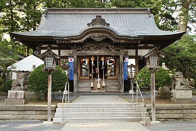
Shrine or Temple 885 m
Kumano Jinja
熊野神社
Aomori ·12 incidents
Park 885 m
Shichinohe Machijuu Ou Kouen
七戸町中央公園
Aomori ·5 incidents
Campground 955 m
Chuuou Kouen Kyanpu Ba
中央公園キャンプ場
Aomori ·20 incidents
School 1.4 km
Shichinohe Chouritsu Tenma Nishi Shougakkou
七戸町立天間西小学校
Aomori ·7 incidents
Train Station 1.7 km
Shichinohe-Towada
Aomori ·47 incidents
Comments (0)
No comments yet.
Hiking in bear country
Safety picks and trail essentials, top-rated on Amazon and Rakuten.