Kumamap Kumamap Kumamap
Map Areas Trip Planner Sponsor Alerts Report
English 日本語 한국어 简体中文 繁體中文 ไทย
Sign in
Sign in
Map Areas Trip Planner Sponsor Alerts Report
English 日本語 한국어 简体中文 繁體中文 ไทย
  1. Home
  2. Fukushima
  3. Kitakata
  4. Kitakata 松山町鳥見山
Incident photo 1

Official Black Bear Kitakata 松山町鳥見山, Fukushima Jun 7, 2026, 09:05 AM

0 views
Saw one too? Report it

Location

Description

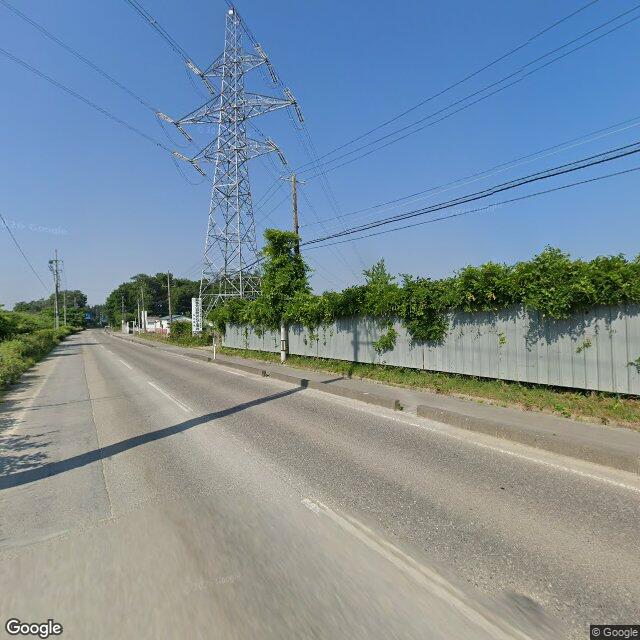
On Sunday, June 7 at about 6:05 p.m., in the Matsubara area of Torimiyama, Matsuyama Town, Kitakata City, a witness (woman in her 40s) was driving north on the prefectural road when she spotted one bear (about 50 cm in length) crossing the road from west to east. The bear ran off to the east and its subsequent whereabouts are unknown.

Note: Official sources provide information in Japanese only. This description has been machine translated for your convenience.

Bear Type

Black Bear

Number of Bears

1

Provider Type

Official

Date & Time

Sunday, June 7, 2026 at 09:05 AM

Address

Kitakata 松山町鳥見山, Fukushima

Coordinates

37.705175, 139.877378

Sources

https://www.rfc.jp/spe/kuma/

Related Areas

Fukushima
Very High Risk

Fukushima

5,976 incidents

Lake Hibara
Moderate Risk

Lake Hibara

Fukushima

984 incidents

Kitakata
Low Risk

Kitakata

Fukushima

470 incidents

Bandai-Asahi National Park
Low Risk

Bandai-Asahi National Park

Niigata

190 incidents

Fukushima
Very High Risk

Fukushima

5,976 incidents

Lake Hibara
Moderate Risk

Lake Hibara

Fukushima

984 incidents

Kitakata
Low Risk

Kitakata

Fukushima

470 incidents

Bandai-Asahi National Park
Low Risk

Bandai-Asahi National Park

Niigata

190 incidents

Nearby places of interest

Mountain 4.7 km

Takamori Yama

高森山

Fukushima ·123 incidents

Mountain 4.7 km

Takamori Yama

高森山

Fukushima ·123 incidents

Comments (0)

0/2000

No comments yet.

Plan Your Trip Risk Map

Hiking in bear country

Safety picks and trail essentials, top-rated on Amazon and Rakuten.

Nearby Incidents

Official

Kitakata 松山町鳥見山, Fukushima

7 m

2 years ago

Official

Kitakata 松山町鳥見山, Fukushima

358 m

7 months ago

Official

Kitakata 松山町鳥見山, Fukushima

405 m

3 years ago

Official

Kitakata 松山町鳥見山, Fukushima

416 m

1 month ago

News

Kitakata 松山町鳥見山, Fukushima

452 m

1 month ago

Kitakata 松山町鳥見山, Fukushima
Official

Kitakata 松山町鳥見山, Fukushima

500 m

7 months ago

Official

Kitakata 熱塩加納町山田, Fukushima

504 m

3 years ago

Official

Kitakata 松山町鳥見山, Fukushima

524 m

3 years ago

Official

Kitakata 松山町鳥見山, Fukushima

7 m

2 years ago

Official

Kitakata 松山町鳥見山, Fukushima

358 m

7 months ago

Official

Kitakata 松山町鳥見山, Fukushima

405 m

3 years ago

Official

Kitakata 松山町鳥見山, Fukushima

416 m

1 month ago

News

Kitakata 松山町鳥見山, Fukushima

452 m

1 month ago

Kitakata 松山町鳥見山, Fukushima
Official

Kitakata 松山町鳥見山, Fukushima

500 m

7 months ago

Official

Kitakata 熱塩加納町山田, Fukushima

504 m

3 years ago

Official

Kitakata 松山町鳥見山, Fukushima

524 m

3 years ago

Kumamap Kumamap

Track bear incidents across Japan. Stay safe outdoors.

Explore

Map Account Areas Places of Interest Predictions Near Me Trip Planner Trip Reports Community Alerts Gear

Learn

Bear Safety Guides Blog News Data FAQ

Mobile

iOS App Android App LINE WhatsApp

Company

About Contact Report Sponsor

Legal

Privacy Terms Commercial Disclosure
© 2026 Kumamap