Location
Description
One bear was seen moving toward the Yoneshiro River.
Note: Official sources provide information in Japanese only. This description has been machine translated for your convenience.
Bear Type
Black Bear
Number of Bears
1
Provider Type
Official
Date & Time
Tuesday, June 16, 2026 at 09:00 PM
Address
Noshiro Makabechi, Akita
Coordinates
40.214866, 140.055213
Sources
Related Areas

Nearby places of interest
Park 457 m
Makabe Chikou Sono
真壁地公園
Akita ·12 incidents
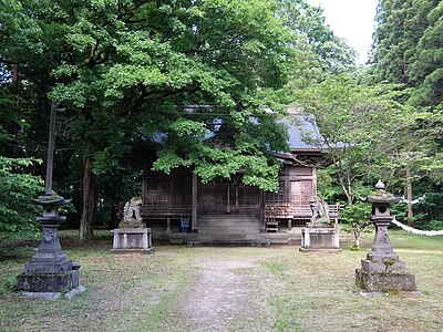
Shrine or Temple 924 m
Jinmei Sha
神明社
Akita ·21 incidents
School 1.5 km
Akitaken Ritsu Noshiro Shien Gakkou
秋田県立能代支援学校
Akita ·23 incidents
School 1.5 km
Noshiro Shiritsu Shinonome ( Shinonome ) Chuugakkou
能代市立東雲(しののめ)中学校
Akita ·92 incidents
Train Station 1.8 km
Mukai-Noshiro
Akita ·116 incidents
Airport 4.4 km
Noshiro R/C Club Airfield
Akita ·223 incidents
Comments (0)
No comments yet.
Hiking in bear country
Safety picks and trail essentials, top-rated on Amazon and Rakuten.
