Kumamap Kumamap Kumamap
Map Areas Predictions Trip Planner Community Alerts Gear
English 日本語 한국어 简体中文 繁體中文 ไทย
Report
Report
Map Areas Predictions Trip Planner Community Alerts Gear
English 日本語 한국어 简体中文 繁體中文 ไทย
  1. Home
  2. Fukushima
  3. Shirakawa
  4. Shirakawa 白坂
Incident photo 1

Official Black Bear Shirakawa 白坂, Fukushima Feb 1, 2026, 02:00 AM

0 views

Location

Description

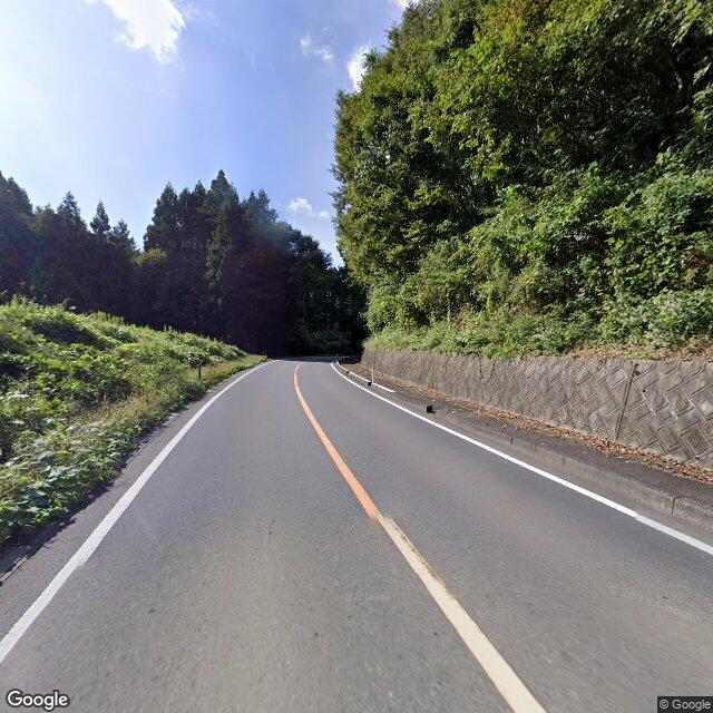
Around 11:00 a.m. on February 1, in the Shirakawa–Shirasaka area on National Route 294, a witness traveling on the highway saw one bear (about 1 m in length) crossing the road from east to west.

Note: Official sources provide information in Japanese only. This description has been machine translated for your convenience.

Bear Type

Black Bear

Number of Bears

1

Provider Type

Official

Date & Time

Sunday, February 1, 2026 at 02:00 AM

Address

Shirakawa 白坂, Fukushima

Coordinates

37.083956, 140.196494

Sources

https://www.rfc.jp/kuma/

Related Areas

Fukushima
Very High

Fukushima

5,359 incidents

Nasu Animal Kingdom
Moderate

Nasu Animal Kingdom

Tochigi

332 incidents

Nasu Highlands
Moderate

Nasu Highlands

Tochigi

308 incidents

Komine Castle
Moderate

Komine Castle

Fukushima

265 incidents

Shirakawa
Low

Shirakawa

Fukushima

91 incidents

Tanagura Castle
Low

Tanagura Castle

Fukushima

51 incidents

Fukushima
Very High

Fukushima

5,359 incidents

Nasu Animal Kingdom
Moderate

Nasu Animal Kingdom

Tochigi

332 incidents

Nasu Highlands
Moderate

Nasu Highlands

Tochigi

308 incidents

Komine Castle
Moderate

Komine Castle

Fukushima

265 incidents

Shirakawa
Low

Shirakawa

Fukushima

91 incidents

Tanagura Castle
Low

Tanagura Castle

Fukushima

51 incidents

Comments (1)

0/2000

Sarah K 2 months ago

crossing a major highway in daylight

Plan Your Trip View Risk Map

Hiking in bear country

Safety picks and trail essentials, top-rated on Amazon and Rakuten.

Nearby Incidents

Official

Shirakawa 白坂, Fukushima

602 m away

3 months ago

Official

Shirakawa 白坂, Fukushima

1.1 km away

6 months ago

News

Jinba, Shirasaka, Shirakawa City, Fukushima

1.1 km away

6 months ago

Official

Shirakawa 白坂, Fukushima

1.2 km away

6 months ago

Official

Shirakawa 白坂, Fukushima

1.5 km away

1 year ago

News

Shirasaka, Shirakawa City (Route 294), Fukushima

1.8 km away

3 months ago

News

Shirasaka, Shirakawa City, Fukushima

1.8 km away

3 months ago

News

Shirasaka, Shirakawa City, Fukushima

1.8 km away

3 months ago

Official

Shirakawa 白坂, Fukushima

602 m away

3 months ago

Official

Shirakawa 白坂, Fukushima

1.1 km away

6 months ago

News

Jinba, Shirasaka, Shirakawa City, Fukushima

1.1 km away

6 months ago

Official

Shirakawa 白坂, Fukushima

1.2 km away

6 months ago

Official

Shirakawa 白坂, Fukushima

1.5 km away

1 year ago

News

Shirasaka, Shirakawa City (Route 294), Fukushima

1.8 km away

3 months ago

News

Shirasaka, Shirakawa City, Fukushima

1.8 km away

3 months ago

News

Shirasaka, Shirakawa City, Fukushima

1.8 km away

3 months ago

Kumamap Kumamap

Track bear incidents across Japan. Stay safe outdoors.

Explore

Map Areas Predictions Near Me Trip Planner Trip Reports Community Alerts Gear

Learn

Bear Safety Guides Blog News Data FAQ

Mobile

iOS App Android App LINE WhatsApp

Company

About Contact Report Advertise

Legal

Privacy Terms Commercial Disclosure

Our Partners

mistweaverco.com
© 2026 Kumamap