Kumamap Kumamap Kumamap
Map Areas Trip Planner Sponsor Alerts Report
English 日本語 한국어 简体中文 繁體中文 ไทย
Sign in
Sign in
Map Areas Trip Planner Sponsor Alerts Report
English 日本語 한국어 简体中文 繁體中文 ไทย
  1. Home
  2. Niigata
  3. Sanjo
  4. Sanjo 荻堀
Incident photo 1

Official Black Bear Sanjo 荻堀, Niigata Nov 27, 2025, 11:40 PM

0 views
Saw one too? Report it

Location

Description

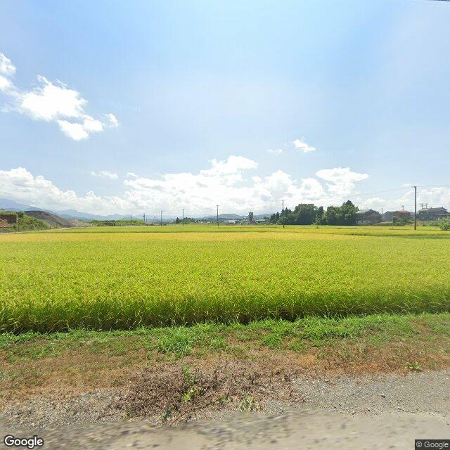
[Post] A bear heading toward the river was sighted in the Ogihori area near Shimoda Bridge.

Note: Official sources provide information in Japanese only. This description has been machine translated for your convenience.

Bear Type

Black Bear

Number of Bears

1

Provider Type

Official

Date & Time

Thursday, November 27, 2025 at 11:40 PM

Address

Sanjo 荻堀, Niigata

Coordinates

37.567854, 139.036934

Sources

https://www.arcgis.com/apps/dashboards/20b4d06fb3b34776959a4...

Related Areas

Niigata
Very High Risk

Niigata

16,320 incidents

Sanjo
Low Risk

Sanjo

Niigata

633 incidents

Niigata
Very High Risk

Niigata

16,320 incidents

Sanjo
Low Risk

Sanjo

Niigata

633 incidents

Nearby places of interest

School 381 m

Sanjou Shiritsu Shimoda Chuugakkou

三条市立 下田中学校

Niigata ·46 incidents

Attraction 901 m

Shimoda Sato Shiryoukan

下田郷資料館

Niigata ·74 incidents

School 1.2 km

Sanjou Shiritsu Iida Shougakkou

三条市立 飯田小学校

Niigata ·51 incidents

School 1.2 km

Sanjou Shiritsu Nagasawa Shougakkou

三条市立 長沢小学校

Niigata ·46 incidents

Comments (1)

0/2000

Lorelei NeutralLisa Wischofskyhttps://www.figma.com/community/file/1198749693280469639https://creativecommons.org/publicdomain/zero/1.0/Remix of „Lorelei Neutral” (https://www.figma.com/community/file/1198749693280469639) by „Lisa Wischofsky”, licensed under „CC0 1.0” (https://creativecommons.org/publicdomain/zero/1.0/)
2381 6 months ago

Heading toward the river rather than away from the settlement is an unusual direction for these sightings in that area.

Plan Your Trip Risk Map

Hiking in bear country

Safety picks and trail essentials, top-rated on Amazon and Rakuten.

Nearby Incidents

Official

Sanjo 荻堀, Niigata

3 m

6 months ago

Official

Sanjo 荻堀, Niigata

424 m

4 years ago

Official

Sanjo 荻堀, Niigata

572 m

9 months ago

Official

Sanjo 荻堀, Niigata

572 m

9 months ago

Official

Sanjo 桑切, Niigata

582 m

9 months ago

Official

Sanjo 荻堀, Niigata

583 m

6 years ago

Official

Sanjo 桑切, Niigata

585 m

9 months ago

Official

Sanjo 荻堀, Niigata

669 m

5 years ago

Official

Sanjo 荻堀, Niigata

3 m

6 months ago

Official

Sanjo 荻堀, Niigata

424 m

4 years ago

Official

Sanjo 荻堀, Niigata

572 m

9 months ago

Official

Sanjo 荻堀, Niigata

572 m

9 months ago

Official

Sanjo 桑切, Niigata

582 m

9 months ago

Official

Sanjo 荻堀, Niigata

583 m

6 years ago

Official

Sanjo 桑切, Niigata

585 m

9 months ago

Official

Sanjo 荻堀, Niigata

669 m

5 years ago

Kumamap Kumamap

Track bear incidents across Japan. Stay safe outdoors.

Explore

Map Account Areas Places of Interest Predictions Near Me Trip Planner Trip Reports Community Alerts Gear

Learn

Bear Safety Guides Blog News Data FAQ

Mobile

iOS App Android App LINE WhatsApp

Company

About Contact Report Sponsor

Legal

Privacy Terms Commercial Disclosure
© 2026 Kumamap