Kumamap Kumamap Kumamap
Map Areas Trip Planner Sponsor Alerts Report
English 日本語 한국어 简体中文 繁體中文 ไทย
Sign in
Sign in
Map Areas Trip Planner Sponsor Alerts Report
English 日本語 한국어 简体中文 繁體中文 ไทย
  1. Home
  2. Aomori
  3. Gonohe
  4. Gonohe 扇田
Incident photo 1

Official Black Bear Gonohe 扇田, Aomori Jun 12, 2026, 09:50 AM

0 views
Saw one too? Report it

Location

Description

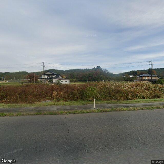
Crossed National Route 4 above Oasis, moving from west to east. One bear about 80 cm (high).

Note: Official sources provide information in Japanese only. This description has been machine translated for your convenience.

Bear Type

Black Bear

Number of Bears

1

Provider Type

Official

Date & Time

Friday, June 12, 2026 at 09:50 AM

Address

Gonohe 扇田, Aomori

Coordinates

40.490370, 141.320912

Sources

https://kumalog-aomori.info/sightings

Related Areas

Aomori
Very High Risk

Aomori

8,538 incidents

Ne Castle
High Risk

Ne Castle

Aomori

1,056 incidents

Miyagi Shrine
High Risk

Miyagi Shrine

Aomori

1,020 incidents

Hachinohe Castle
High Risk

Hachinohe Castle

Aomori

1,020 incidents

Ogami Shrine
High Risk

Ogami Shrine

Aomori

1,018 incidents

Korekawa Site
High Risk

Korekawa Site

Aomori

1,006 incidents

Oirase River
High Risk

Oirase River

Aomori

716 incidents

Gonohe
Low Risk

Gonohe

Aomori

115 incidents

Aomori
Very High Risk

Aomori

8,538 incidents

Ne Castle
High Risk

Ne Castle

Aomori

1,056 incidents

Miyagi Shrine
High Risk

Miyagi Shrine

Aomori

1,020 incidents

Hachinohe Castle
High Risk

Hachinohe Castle

Aomori

1,020 incidents

Ogami Shrine
High Risk

Ogami Shrine

Aomori

1,018 incidents

Korekawa Site
High Risk

Korekawa Site

Aomori

1,006 incidents

Oirase River
High Risk

Oirase River

Aomori

716 incidents

Gonohe
Low Risk

Gonohe

Aomori

115 incidents

Comments (0)

0/2000

No comments yet.

Plan Your Trip Risk Map

Hiking in bear country

Safety picks and trail essentials, top-rated on Amazon and Rakuten.

Nearby Incidents

Official

Gonohe 扇田, Aomori

234 m

6 years ago

Official

Gonohe 扇田, Aomori

261 m

11 months ago

Official

Gonohe 扇田, Aomori

853 m

1 year ago

Official

Gonohe 扇田, Aomori

999 m

1 year ago

Official

Gonohe 下長下タ, Aomori

1.2 km

6 years ago

Official

Gonohe 豊間内, Aomori

1.8 km

7 months ago

Official

Gonohe 豊間内, Aomori

1.9 km

2 years ago

Official

Gonohe 地蔵岱, Aomori

2.0 km

1 year ago

Official

Gonohe 扇田, Aomori

234 m

6 years ago

Official

Gonohe 扇田, Aomori

261 m

11 months ago

Official

Gonohe 扇田, Aomori

853 m

1 year ago

Official

Gonohe 扇田, Aomori

999 m

1 year ago

Official

Gonohe 下長下タ, Aomori

1.2 km

6 years ago

Official

Gonohe 豊間内, Aomori

1.8 km

7 months ago

Official

Gonohe 豊間内, Aomori

1.9 km

2 years ago

Official

Gonohe 地蔵岱, Aomori

2.0 km

1 year ago

Kumamap Kumamap

Track bear incidents across Japan. Stay safe outdoors.

Explore

Map Account Areas Places of Interest Predictions Near Me Trip Planner Trip Reports Community Alerts Gear

Learn

Bear Safety Guides Blog News Data FAQ

Mobile

iOS App Android App LINE WhatsApp

Company

About Contact Report Sponsor

Legal

Privacy Terms Commercial Disclosure
© 2026 Kumamap