Kumamap Kumamap Kumamap
Map Areas Trip Planner Sponsor Alerts Report
English 日本語 한국어 简体中文 繁體中文 ไทย
Sign in
Sign in
Map Areas Trip Planner Sponsor Alerts Report
English 日本語 한국어 简体中文 繁體中文 ไทย
  1. Home
  2. Fukushima
  3. Shirakawa
  4. Shirakawa 大信上新城
Incident photo 1

Official Black Bear Shirakawa 大信上新城, Fukushima Jun 22, 2026, 10:19 PM

0 views
Saw one too? Report it

Location

Description

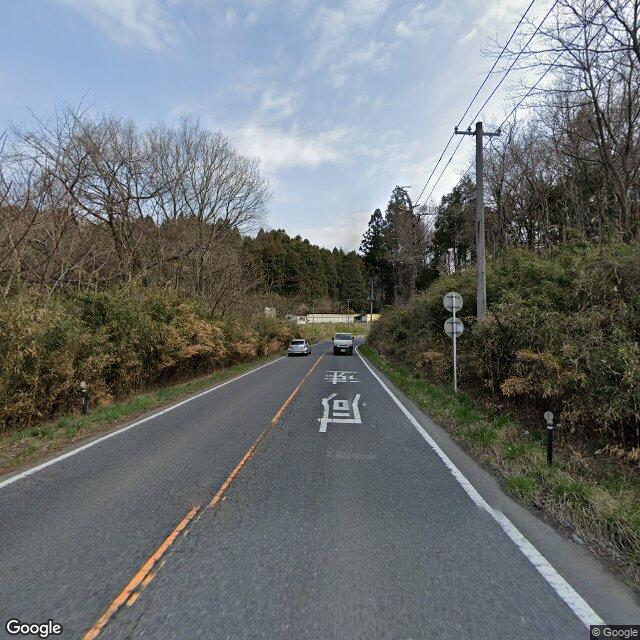
On Tuesday, June 23 at approximately 7:19 a.m., on the road in Ikenoue, Oshinjo, Daishin, Shirakawa City, a man in his 40s, while driving, saw one bear (about 1 m in length) cross the road and head into the forest.

Note: Official sources provide information in Japanese only. This description has been machine translated for your convenience.

Bear Type

Black Bear

Number of Bears

1

Provider Type

Official

Date & Time

Monday, June 22, 2026 at 10:19 PM

Address

Shirakawa 大信上新城, Fukushima

Coordinates

37.218507, 140.250405

Sources

https://www.rfc.jp/spe/kuma/

Related Areas

Fukushima
Very High Risk

Fukushima

5,995 incidents

Komine Castle
Moderate Risk

Komine Castle

Fukushima

299 incidents

Shirakawa
Low Risk

Shirakawa

Fukushima

97 incidents

Fukushima
Very High Risk

Fukushima

5,995 incidents

Komine Castle
Moderate Risk

Komine Castle

Fukushima

299 incidents

Shirakawa
Low Risk

Shirakawa

Fukushima

97 incidents

Nearby places of interest

Mountain 1.8 km

Tanba Tateyama

丹波楯山

Fukushima ·28 incidents

Mountain 1.8 km

Tanba Tateyama

丹波楯山

Fukushima ·28 incidents

Comments (0)

0/2000

No comments yet.

Plan Your Trip Risk Map

Hiking in bear country

Safety picks and trail essentials, top-rated on Amazon and Rakuten.

Nearby Incidents

Official

Shirakawa 大信町屋, Fukushima

773 m

3 years ago

Official

Shirakawa 大信町屋, Fukushima

773 m

3 years ago

Official

Ten-ei, Fukushima

773 m

2 years ago

Official

Shirakawa 大信中新城, Fukushima

2.1 km

1 year ago

Official

Shirakawa 大信中新城, Fukushima

2.2 km

2 years ago

Official

Shirakawa 大信下小屋, Fukushima

2.4 km

4 years ago

Official

Shirakawa 大信下小屋, Fukushima

2.4 km

4 years ago

Official

Shirakawa 大信増見, Fukushima

2.6 km

1 week ago

Official

Shirakawa 大信町屋, Fukushima

773 m

3 years ago

Official

Shirakawa 大信町屋, Fukushima

773 m

3 years ago

Official

Ten-ei, Fukushima

773 m

2 years ago

Official

Shirakawa 大信中新城, Fukushima

2.1 km

1 year ago

Official

Shirakawa 大信中新城, Fukushima

2.2 km

2 years ago

Official

Shirakawa 大信下小屋, Fukushima

2.4 km

4 years ago

Official

Shirakawa 大信下小屋, Fukushima

2.4 km

4 years ago

Official

Shirakawa 大信増見, Fukushima

2.6 km

1 week ago

Kumamap Kumamap

Track bear incidents across Japan. Stay safe outdoors.

Explore

Map Account Areas Places of Interest Predictions Near Me Trip Planner Trip Reports Community Alerts Gear

Learn

Bear Safety Guides Blog News Data FAQ

Mobile

iOS App Android App LINE WhatsApp

Company

About Contact Report Sponsor

Legal

Privacy Terms Commercial Disclosure
© 2026 Kumamap