Kumamap Kumamap Kumamap
Map Areas Predictions Trip Planner Community Alerts Gear
English 日本語 한국어 简体中文 繁體中文 ไทย
Report
Report
Map Areas Predictions Trip Planner Community Alerts Gear
English 日本語 한국어 简体中文 繁體中文 ไทย
  1. Home
  2. Shiga
  3. Kusatsu
  4. Kusatsu Wakakusa 4-chome
Incident photo 1

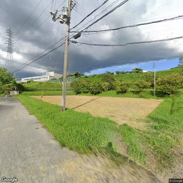
Official Black Bear Kusatsu Wakakusa 4-chome, Shiga Dec 8, 2025, 05:30 PM

0 views

Location

Description

Moved east.

Note: Official sources provide information in Japanese only. This description has been machine translated for your convenience.

Bear Type

Black Bear

Number of Bears

1

Provider Type

Official

Date & Time

Monday, December 8, 2025 at 05:30 PM

Address

Kusatsu Wakakusa 4-chome, Shiga

Coordinates

34.985675, 135.973094

Sources

https://www.google.com/maps/d/u/0/viewer?mid=1rE5HcSdJnm2gX3...

Related Areas

Seiken-ji Temple
Low Risk

Seiken-ji Temple

Kyoto

408 incidents

Shugaku-in Imperial Villa
Low Risk

Shugaku-in Imperial Villa

Kyoto

402 incidents

Konpuku-ji Temple
Low Risk

Konpuku-ji Temple

Kyoto

399 incidents

Shisen-dō Temple
Low Risk

Shisen-dō Temple

Kyoto

399 incidents

Manshu-in Temple
Low Risk

Manshu-in Temple

Kyoto

397 incidents

National Museum of Modern Art, Kyoto
Low Risk

National Museum of Modern Art, Kyoto

Kyoto

392 incidents

Yoshida Shrine
Low Risk

Yoshida Shrine

Kyoto

391 incidents

Okazaki Park
Low Risk

Okazaki Park

Kyoto

390 incidents

Seiken-ji Temple
Low Risk

Seiken-ji Temple

Kyoto

408 incidents

Shugaku-in Imperial Villa
Low Risk

Shugaku-in Imperial Villa

Kyoto

402 incidents

Konpuku-ji Temple
Low Risk

Konpuku-ji Temple

Kyoto

399 incidents

Shisen-dō Temple
Low Risk

Shisen-dō Temple

Kyoto

399 incidents

Manshu-in Temple
Low Risk

Manshu-in Temple

Kyoto

397 incidents

National Museum of Modern Art, Kyoto
Low Risk

National Museum of Modern Art, Kyoto

Kyoto

392 incidents

Yoshida Shrine
Low Risk

Yoshida Shrine

Kyoto

391 incidents

Okazaki Park
Low Risk

Okazaki Park

Kyoto

390 incidents

Comments (0)

0/2000

No comments yet.

Plan Your Trip View Risk Map

Hiking in bear country

Safety picks and trail essentials, top-rated on Amazon and Rakuten.

Nearby Incidents

Official

Otsu Aoyama 3-chome, Shiga

525 m away

11 months ago

News

Okamotocho, Kusatsu City, Shiga

932 m away

5 months ago

Official

Kusatsu Banbacho, Shiga

1.2 km away

11 months ago

Official

Otsu Maki 1-chome, Shiga

3.0 km away

11 months ago

Community

Ritto 安養寺四丁目, Shiga

4.4 km away

4 months ago

Official

Otsu, Shiga

6.9 km away

1 year ago

Official

Otsu Akibadai, Shiga

8.2 km away

8 months ago

Official

Otsu Zeze-hiraocho, Shiga

8.5 km away

1 year ago

Official

Otsu Aoyama 3-chome, Shiga

525 m away

11 months ago

News

Okamotocho, Kusatsu City, Shiga

932 m away

5 months ago

Official

Kusatsu Banbacho, Shiga

1.2 km away

11 months ago

Official

Otsu Maki 1-chome, Shiga

3.0 km away

11 months ago

Community

Ritto 安養寺四丁目, Shiga

4.4 km away

4 months ago

Official

Otsu, Shiga

6.9 km away

1 year ago

Official

Otsu Akibadai, Shiga

8.2 km away

8 months ago

Official

Otsu Zeze-hiraocho, Shiga

8.5 km away

1 year ago

Kumamap Kumamap

Track bear incidents across Japan. Stay safe outdoors.

Explore

Map Areas Predictions Near Me Trip Planner Trip Reports Community Alerts Gear

Learn

Bear Safety Guides Blog News Data FAQ

Mobile

iOS App Android App LINE WhatsApp

Company

About Contact Report Advertise

Legal

Privacy Terms Commercial Disclosure

Our Partners

mistweaverco.com
© 2026 Kumamap