Kumamap Kumamap Kumamap
Map Areas Trip Planner Sponsor Alerts Report
English 日本語 한국어 简体中文 繁體中文 ไทย
Sign in
Sign in
Map Areas Trip Planner Sponsor Alerts Report
English 日本語 한국어 简体中文 繁體中文 ไทย
  1. Home
  2. Fukushima
  3. Miharu
  4. Tatenokoshi area, Omatsuri, Miharu Town, Fukushima Prefecture
Incident photo 1

News Black Bear Tatenokoshi area, Omatsuri, Miharu Town, Fukushima Prefecture, Fukushima Dec 23, 2025, 05:30 AM

0 views
Saw one too? Report it

Location

Description

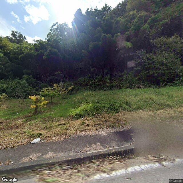
At around 05:30 on the 23rd, one bear about 1 meter long was sighted on fields near Tatenokoshi area, Omatsuri, Miharu Town. The bear left for the forest and no damage to people or property has been reported; the police are urging caution.

Note: Official sources provide information in Japanese only. This description has been machine translated for your convenience.

Bear Type

Black Bear

Number of Bears

1

Provider Type

News

Date & Time

Tuesday, December 23, 2025 at 05:30 AM

Address

Tatenokoshi area, Omatsuri, Miharu Town, Fukushima Prefecture, Fukushima

Coordinates

37.459575, 140.489953

Sources

https://news.ntv.co.jp/n/fct/category/society/fc15c4b087e29f...

Related Areas

Fukushima
High Risk

Fukushima

5,333 incidents

Nihonmatsu Castle
Moderate Risk

Nihonmatsu Castle

Fukushima

961 incidents

Miharu
Low Risk

Miharu

Fukushima

14 incidents

Fukushima
High Risk

Fukushima

5,333 incidents

Nihonmatsu Castle
Moderate Risk

Nihonmatsu Castle

Fukushima

961 incidents

Miharu
Low Risk

Miharu

Fukushima

14 incidents

Nearby places of interest

School 1.4 km

Fukushima Kenritsu Tamura Koutougakkou

福島県立田村高等学校

Fukushima ·6 incidents

Train Station 1.4 km

Miharu

Fukushima ·7 incidents

Castle 2.0 km

Miharu Shiro

三春城

Fukushima ·11 incidents

School 1.4 km

Fukushima Kenritsu Tamura Koutougakkou

福島県立田村高等学校

Fukushima ·6 incidents

Train Station 1.4 km

Miharu

Fukushima ·7 incidents

Castle 2.0 km

Miharu Shiro

三春城

Fukushima ·11 incidents

Comments (1)

0/2000

Lorelei NeutralLisa Wischofskyhttps://www.figma.com/community/file/1198749693280469639https://creativecommons.org/publicdomain/zero/1.0/Remix of „Lorelei Neutral” (https://www.figma.com/community/file/1198749693280469639) by „Lisa Wischofsky”, licensed under „CC0 1.0” (https://creativecommons.org/publicdomain/zero/1.0/)
Akira 5 months ago

Early morning sighting in the fields there. Wonder if it comes back to that same area or just passing through Tatenokoshi.

Plan Your Trip Risk Map

Hiking in bear country

Safety picks and trail essentials, top-rated on Amazon and Rakuten.

Nearby Incidents

Miharu 大字御祭, Fukushima
Official

Miharu 大字御祭, Fukushima

104 m

5 months ago

Miharu 大字御祭, Fukushima
Official

Miharu 大字御祭, Fukushima

207 m

5 months ago

News

Fukatawa, Miharu Town, Fukushima

629 m

7 months ago

Official

Miharu 字四反田, Fukushima

682 m

7 months ago

Miharu 字大町, Fukushima
News

Miharu 字大町, Fukushima

2.1 km

2 months ago

Miharu 字大町, Fukushima
News

Miharu 字大町, Fukushima

2.1 km

2 months ago

News

Tamura Funehikimachi-Kanameta, Fukushima

3.1 km

2 weeks ago

Serigazawa, Miharu Town, Fukushima
News

Serigazawa, Miharu Town, Fukushima

3.4 km

3 months ago

Miharu 大字御祭, Fukushima
Official

Miharu 大字御祭, Fukushima

104 m

5 months ago

Miharu 大字御祭, Fukushima
Official

Miharu 大字御祭, Fukushima

207 m

5 months ago

News

Fukatawa, Miharu Town, Fukushima

629 m

7 months ago

Official

Miharu 字四反田, Fukushima

682 m

7 months ago

Miharu 字大町, Fukushima
News

Miharu 字大町, Fukushima

2.1 km

2 months ago

Miharu 字大町, Fukushima
News

Miharu 字大町, Fukushima

2.1 km

2 months ago

News

Tamura Funehikimachi-Kanameta, Fukushima

3.1 km

2 weeks ago

Serigazawa, Miharu Town, Fukushima
News

Serigazawa, Miharu Town, Fukushima

3.4 km

3 months ago

Kumamap Kumamap

Track bear incidents across Japan. Stay safe outdoors.

Explore

Map Account Areas Places of Interest Predictions Near Me Trip Planner Trip Reports Community Alerts Gear

Learn

Bear Safety Guides Blog News Data FAQ

Mobile

iOS App Android App LINE WhatsApp

Company

About Contact Report Sponsor

Legal

Privacy Terms Commercial Disclosure
© 2026 Kumamap