Kumamap Kumamap Kumamap
Map Areas Trip Planner Sponsor Alerts Report
English 日本語 한국어 简体中文 繁體中文 ไทย
Sign in
Sign in
Map Areas Trip Planner Sponsor Alerts Report
English 日本語 한국어 简体中文 繁體中文 ไทย
  1. Home
  2. Akita
  3. Yokote
  4. Yokote 増田町亀田
Incident photo 1

Official Black Bear Yokote 増田町亀田, Akita Mar 2, 2026, 05:40 AM

0 views
Saw one too? Report it

Location

Description

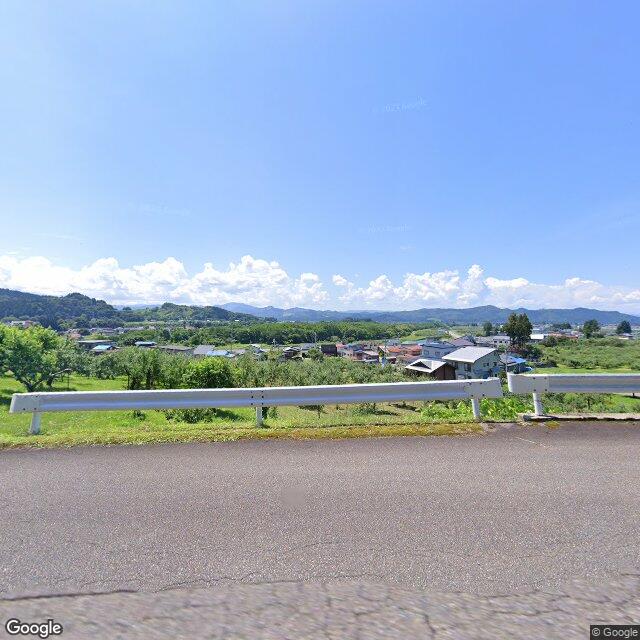
One cub was wandering around an apple orchard. When approached by people, it climbed the slope of Mount Shinjō (East) and fled. About 60 cm in body length. The distance to the nearest house was about 80 m.

Note: Official sources provide information in Japanese only. This description has been machine translated for your convenience.

Bear Type

Black Bear

Number of Bears

1

Provider Type

Official

Date & Time

Monday, March 2, 2026 at 05:40 AM

Address

Yokote 増田町亀田, Akita

Coordinates

39.207307, 140.573109

Sources

https://kumadas.net

Related Areas

Akita
Very High Risk

Akita

23,135 incidents

Yokote
Very High Risk

Yokote

Akita

1,148 incidents

Akita
Very High Risk

Akita

23,135 incidents

Yokote
Very High Risk

Yokote

Akita

1,148 incidents

Nearby places of interest

Park 171 m

Masato Kouen

真人公園

Akita ·17 incidents

Community Centre 262 m

Ikoino Kan

いこいの館

Akita ·28 incidents

Community Centre 434 m

Nishinari Se Chiku Kouryuu Sentaa

西成瀬地区交流センター

Akita ·39 incidents

Attraction 623 m

Masuda Suiryoku Denki Masato Hatsudensho Ato

増田水力電気 真人発電所跡

Akita ·51 incidents

Mountain 834 m

Mt. Mato

Akita ·135 incidents

Shrine or Temple 1.2 km

Katakura Jinja

片倉神社

Akita ·35 incidents

Community Centre 1.3 km

Kameda Chiku Kouryuu Sentaa

亀田地区交流センター

Akita ·18 incidents

Shrine or Temple 1.3 km

Hana Kan Jinja

花館神社

Akita ·21 incidents

Comments (1)

0/2000

Lorelei NeutralLisa Wischofskyhttps://www.figma.com/community/file/1198749693280469639https://creativecommons.org/publicdomain/zero/1.0/Remix of „Lorelei Neutral” (https://www.figma.com/community/file/1198749693280469639) by „Lisa Wischofsky”, licensed under „CC0 1.0” (https://creativecommons.org/publicdomain/zero/1.0/)
石井あかね 3 months ago

子グマだけの目撃って、母グマはどこにいたんだろう。

Plan Your Trip Risk Map

Hiking in bear country

Safety picks and trail essentials, top-rated on Amazon and Rakuten.

Nearby Incidents

Official

Yokote 増田町亀田, Akita

13 m

10 months ago

Official

Yokote 増田町亀田, Akita

68 m

3 months ago

Official

Yokote 増田町亀田, Akita

144 m

4 months ago

Official

Yokote 増田町亀田, Akita

218 m

4 months ago

Official

Yokote 増田町亀田, Akita

227 m

2 years ago

Official

Yokote 増田町亀田, Akita

249 m

4 months ago

Official

Yokote 増田町亀田, Akita

262 m

8 months ago

Official

Yokote 増田町亀田, Akita

388 m

7 months ago

Official

Yokote 増田町亀田, Akita

13 m

10 months ago

Official

Yokote 増田町亀田, Akita

68 m

3 months ago

Official

Yokote 増田町亀田, Akita

144 m

4 months ago

Official

Yokote 増田町亀田, Akita

218 m

4 months ago

Official

Yokote 増田町亀田, Akita

227 m

2 years ago

Official

Yokote 増田町亀田, Akita

249 m

4 months ago

Official

Yokote 増田町亀田, Akita

262 m

8 months ago

Official

Yokote 増田町亀田, Akita

388 m

7 months ago

Kumamap Kumamap

Track bear incidents across Japan. Stay safe outdoors.

Explore

Map Account Areas Places of Interest Predictions Near Me Trip Planner Trip Reports Community Alerts Gear

Learn

Bear Safety Guides Blog News Data FAQ

Mobile

iOS App Android App LINE WhatsApp

Company

About Contact Report Sponsor

Legal

Privacy Terms Commercial Disclosure
© 2026 Kumamap