Kumamap Kumamap Kumamap
Map Areas Predictions Trip Planner Community Alerts Gear
English 日本語 한국어 简体中文 繁體中文 ไทย
Report
Report
Map Areas Predictions Trip Planner Community Alerts Gear
English 日本語 한국어 简体中文 繁體中文 ไทย
  1. Home
  2. Fukushima
  3. Kitakata
  4. Takenohana Park (Shiokawa, Kitakata City)
Incident photo 1

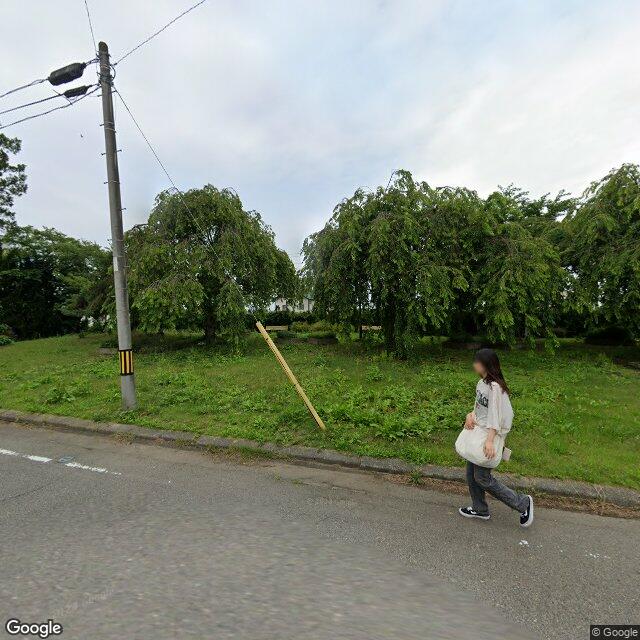
News Black Bear Takenohana Park (Shiokawa, Kitakata City), Fukushima Nov 28, 2025, 03:04 AM

0 views

Location

Description

At around 03:04 on the 28th, a man in his 70s delivering newspapers spotted a single bear about 1 meter long in Takenohana Park, Shiokawa, Kitakata City, Fukushima. The bear's subsequent whereabouts are unknown, and no injuries or property damage have been reported.

Note: Official sources provide information in Japanese only. This description has been machine translated for your convenience.

Summary

In the early hours of the 28th, a man in his 70s delivering newspapers spotted a roughly 1-meter-long bear in Takenohana Park in Shiokawa, Kitakata City. The police have shared information with the city and are conducting patrols and public notices near the scene, and no injuries or property damage have been reported.

Bear Type

Black Bear

Number of Bears

1

Provider Type

News

Date & Time

Friday, November 28, 2025 at 03:04 AM

Address

Takenohana Park (Shiokawa, Kitakata City), Fukushima

Coordinates

37.595308, 139.887513

Sources

https://news.yahoo.co.jp/articles/6c99b0558e563aea2622578a86...

Related Areas

Fukushima
Very High

Fukushima

5,369 incidents

Fukushima Museum
Moderate

Fukushima Museum

Fukushima

1,613 incidents

Aizuwakamatsu Castle
Moderate

Aizuwakamatsu Castle

Fukushima

1,609 incidents

Kitakata
Low

Kitakata

Fukushima

457 incidents

Fukushima
Very High

Fukushima

5,369 incidents

Fukushima Museum
Moderate

Fukushima Museum

Fukushima

1,613 incidents

Aizuwakamatsu Castle
Moderate

Aizuwakamatsu Castle

Fukushima

1,609 incidents

Kitakata
Low

Kitakata

Fukushima

457 incidents

Comments (1)

0/2000

森美咲 5 months ago

朝の3時に新聞配達中って、その時間帯が一番危ないんじゃないか。

Plan Your Trip View Risk Map

Hiking in bear country

Safety picks and trail essentials, top-rated on Amazon and Rakuten.

Nearby Incidents

Official

Kitakata 塩川町, Fukushima

11 m away

5 months ago

Official

Kitakata 塩川町御殿場一丁目, Fukushima

357 m away

2 years ago

Official

Kitakata 塩川町, Fukushima

459 m away

2 years ago

Official

Kitakata 塩川町諏訪町二丁目, Fukushima

578 m away

10 months ago

Official

Kitakata 塩川町御殿場三丁目, Fukushima

692 m away

9 months ago

Official

Yugawa 大字浜崎, Fukushima

791 m away

7 months ago

Official

Yugawa 大字浜崎, Fukushima

804 m away

2 years ago

Official

Yugawa 大字浜崎, Fukushima

958 m away

7 months ago

Official

Kitakata 塩川町, Fukushima

11 m away

5 months ago

Official

Kitakata 塩川町御殿場一丁目, Fukushima

357 m away

2 years ago

Official

Kitakata 塩川町, Fukushima

459 m away

2 years ago

Official

Kitakata 塩川町諏訪町二丁目, Fukushima

578 m away

10 months ago

Official

Kitakata 塩川町御殿場三丁目, Fukushima

692 m away

9 months ago

Official

Yugawa 大字浜崎, Fukushima

791 m away

7 months ago

Official

Yugawa 大字浜崎, Fukushima

804 m away

2 years ago

Official

Yugawa 大字浜崎, Fukushima

958 m away

7 months ago

Kumamap Kumamap

Track bear incidents across Japan. Stay safe outdoors.

Explore

Map Areas Predictions Near Me Trip Planner Trip Reports Community Alerts Gear

Learn

Bear Safety Guides Blog News Data FAQ

Mobile

iOS App Android App LINE WhatsApp

Company

About Contact Report Advertise

Legal

Privacy Terms Commercial Disclosure

Our Partners

mistweaverco.com
© 2026 Kumamap