Kumamap Kumamap Kumamap
Map Areas Trip Planner Sponsor Alerts Report
English 日本語 한국어 简体中文 繁體中文 ไทย
Sign in
Sign in
Map Areas Trip Planner Sponsor Alerts Report
English 日本語 한국어 简体中文 繁體中文 ไทย
  1. Home
  2. Fukushima
  3. Otama
  4. Otama Tamanoi
Incident photo 1

Official Black Bear Otama Tamanoi, Fukushima May 24, 2026, 10:40 PM

0 views
Saw one too? Report it

Location

Description

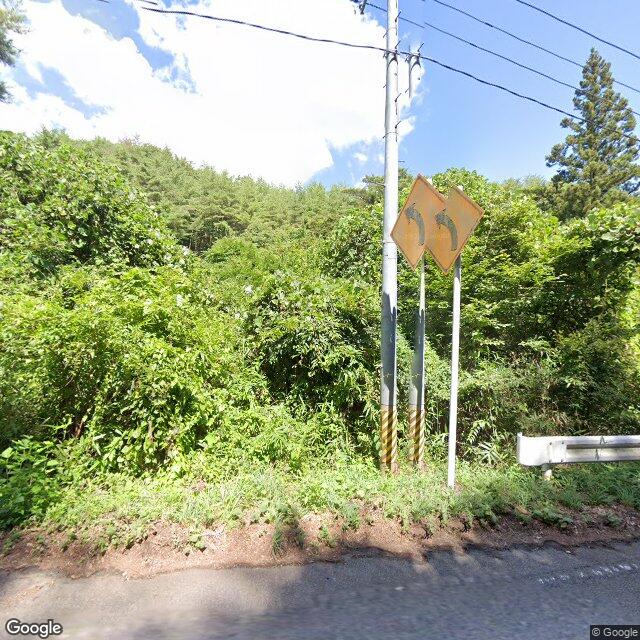
On Monday, May 25 at around 7:40 a.m., on the Ishimayu-Motomiya Prefectural Road in Tamai, Tamura Village, within the Kitakami upland area, a witness (male) driving a vehicle spotted one bear (about 1 m in body length) sitting in the forested area to the north.

Note: Official sources provide information in Japanese only. This description has been machine translated for your convenience.

Bear Type

Black Bear

Number of Bears

1

Provider Type

Official

Date & Time

Sunday, May 24, 2026 at 10:40 PM

Address

Otama Tamanoi, Fukushima

Coordinates

37.543538, 140.321794

Sources

https://www.rfc.jp/spe/kuma/

Related Areas

Fukushima
Very High Risk

Fukushima

5,965 incidents

Nihonmatsu Castle
High Risk

Nihonmatsu Castle

Fukushima

1,073 incidents

Otama
Low Risk

Otama

Fukushima

68 incidents

Fukushima
Very High Risk

Fukushima

5,965 incidents

Nihonmatsu Castle
High Risk

Nihonmatsu Castle

Fukushima

1,073 incidents

Otama
Low Risk

Otama

Fukushima

68 incidents

Nearby places of interest

Hotel 352 m

Ootama Rizootohiruzuhoteru

大玉リゾートヒルズホテル

Fukushima ·12 incidents

Golf Course 532 m

Ootama Kantoriikurabu

大玉カントリークラブ

Fukushima ·12 incidents

Mountain 1.4 km

San Tsu Moriyama

三ツ森山

Fukushima ·96 incidents

Mountain 1.5 km

Yoshimaru Yama

吉丸山

Fukushima ·49 incidents

Mountain 1.5 km

Odaka Kurayama

小高倉山

Fukushima ·90 incidents

Mountain 2.1 km

Moriya Yama

守谷山

Fukushima ·64 incidents

Mountain 2.4 km

Takamatsu Yama

高松山

Fukushima ·78 incidents

Mountain 4.3 km

Daimyou Kurayama

大名倉山

Fukushima ·59 incidents

Comments (0)

0/2000

No comments yet.

Plan Your Trip Risk Map

Hiking in bear country

Safety picks and trail essentials, top-rated on Amazon and Rakuten.

Nearby Incidents

Official

Otama 坂下, Fukushima

425 m

8 months ago

Official

Otama 長井坂, Fukushima

686 m

8 months ago

Official

Otama Tamanoi, Fukushima

758 m

3 weeks ago

Official

Otama 長井坂, Fukushima

1.3 km

7 months ago

Official

Otama シタ林, Fukushima

1.6 km

2 years ago

Official

Otama 長井坂, Fukushima

1.7 km

7 months ago

Official

Otama 長井坂, Fukushima

1.7 km

0 years ago

Otama 新田, Fukushima
Official

Otama 新田, Fukushima

1.7 km

7 months ago

Official

Otama 坂下, Fukushima

425 m

8 months ago

Official

Otama 長井坂, Fukushima

686 m

8 months ago

Official

Otama Tamanoi, Fukushima

758 m

3 weeks ago

Official

Otama 長井坂, Fukushima

1.3 km

7 months ago

Official

Otama シタ林, Fukushima

1.6 km

2 years ago

Official

Otama 長井坂, Fukushima

1.7 km

7 months ago

Official

Otama 長井坂, Fukushima

1.7 km

0 years ago

Otama 新田, Fukushima
Official

Otama 新田, Fukushima

1.7 km

7 months ago

Kumamap Kumamap

Track bear incidents across Japan. Stay safe outdoors.

Explore

Map Account Areas Places of Interest Predictions Near Me Trip Planner Trip Reports Community Alerts Gear

Learn

Bear Safety Guides Blog News Data FAQ

Mobile

iOS App Android App LINE WhatsApp

Company

About Contact Report Sponsor

Legal

Privacy Terms Commercial Disclosure
© 2026 Kumamap