
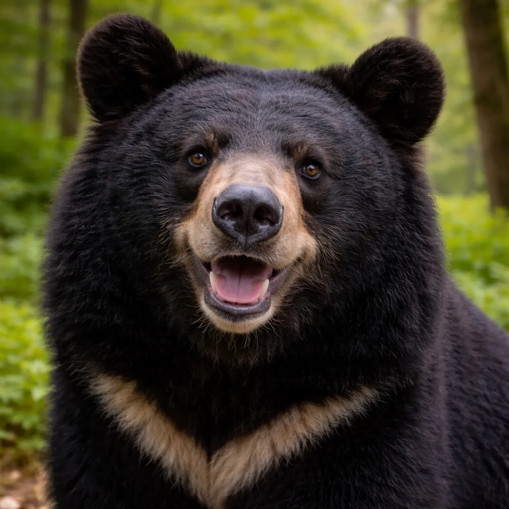
홋카이도 불곰
Ursus arctos yesoensis
- 서식지
- 홋카이도
- 몸무게
- 200~400 kg
- 활동 시간
- 새벽・황혼
안전하게 공존하기
- ·걸으면서 소리를 내어 존재를 알린다
- ·곰 격퇴 스프레이를 휴대; 돌진 시 5m 거리에서 분사
- ·접촉 시 엎드려 손깍지로 목 뒤를 보호한다. 움직임이 멈추면 대개 떠난다
- ·뛰지 말고 나무에도 오르지 말 것
새로운 여행 계획으로 저장됩니다. 원본 리포트는 그대로 유지됩니다.
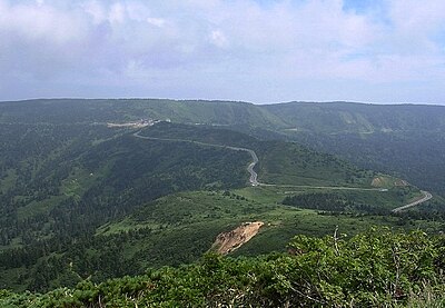
하치만타이에서 시모키타한토 국정공원까지, 이와테현, 아오모리현, 아키타현, 홋카이도을 지나는 총 337 km 경로입니다. 지난 30일 동안 경로 5km 이내에서 곰 출몰이 110건 보고되었습니다. 이 중 최근 7일 동안의 보고는 17건입니다. 가장 최근 출몰은 20시간 전 Hirakawa, Aomori 부근에서 보고되었습니다.
현재 곰 활동이 활발한 회랑입니다. 경로 변경 또는 일정 조정을 강력히 권장합니다.
Climbed a tree. [Issued by Hirakawa City]
Hirakawa, Aomori
When I shone the car's headlights from higher up the slope, I saw the large four-legged shadow run off toward the Akasaka sheet metal area.
Kuroishi 大字三島, Aomori

I can’t say for certain, but when I shone the car’s headlights from the top of the hill I briefly saw a large four-legged shadow running toward the direction of Kuroishi city. Since it was only a silhouette I can’t be sure, but I believe it was at least a large animal.
Kuroishi 大字三島, Aomori
At around 9:00 PM on June 22, one bear was sighted in Akasaka, Kuroishi City.
Kuroishi 大字三島, Aomori

Around 9:00 PM on June 22, one bear was seen moving in Akasaka-Nozaki, Kuroishi City.
Kuroishi 大字三島, Aomori
(From a post) Appeared startled by the car and climbed up the slope.
Kazuno, Akita

Construction site / body length 1 m / 30 m from houses, etc. / approximately 30 m from the witness While walking near a construction site along the national highway, the witness saw a bear cross the railroad tracks from south to north and enter the brush.
Kazuno, Akita
Around 5:50 on June 19, a bear was sighted moving in Hachimantai Azusawaikari, Kazuno City, Akita.
Kazuno, Akita
On private residential property / body length 1 m / 1 m from the house / approximately 3 m from the witness. The witness observed a bear moving through the grassy area from east to west from inside the house.
Kazuno Osarizawa, Akita
Saw one bear cub on the road. Body length about 80 cm. Walked off toward the mountains to the west.
Hirakawa, Aomori
On private residential property / body length 1 m / 2 m from the house / 3 m distance to the witness: A bear was spotted outside the window. The bear slowly moved east. Fearing the window might be broken, the witness quietly moved away from the window and evacuated without provoking the bear, so its subsequent behavior is unknown.
Kazuno Osarizawa, Akita

[Post]
Kosaka, Akita
While driving, a bear about 1 m in body length was sighted in the roadside brush beside the municipal road from inside the vehicle. The subsequent direction of the bear's movement is unknown.
Kazuno Towada-Kusagi, Akita
Around 15:40 on 2026-06-17, a bear was seen moving in Kosakadaisaku, Kosaka Town, Akita Prefecture.
Kosaka, Akita
[Report] On the road from Sunagosawa Water Purification Plant heading into the mountains, one bear about 1 meter was sighted. It ran off into the mountains.
Kosaka, Akita
Report: Spotted one bear about 1 meter in size on the road from Sunagosawa Water Purification Plant toward the mountain. It ran off into the mountain.
Kosaka, Akita

One Asian black bear (Tsukinowaguma) crossed the road and ran west.
Odate, Akita

City road / body length 1 m / 100 m from a private house / 100 m distance to the witness. The bear was seen walking on the city road toward the mountain.
Kazuno Osarizawa, Akita

Report from a citizen. [Sent from Hirakawa City]
Hirakawa Niidate, Aomori

One adult bear and two cubs were crossing the Nishiyama agricultural access road.
Kazuno, Akita

Municipal road / body length 1 m / 20 m from a residence / 50 m distance to witness. A bear was observed roaming near the trash collection area from inside the house.
Kazuno Towada-Okada, Akita

While heading from Goshogawara toward Daishaka, I saw one bear crossing the road just before the Daishaka snow shelter. It was a short distance away but appeared over 1 meter in size.
Goshogawara 大字前田野目, Aomori
On June 15 around 18:08, one bear was seen moving in Maeda Nomenumata, Goshogawara City, Aomori Prefecture.
Goshogawara 大字前田野目, Aomori
[Report] Spotted one bear (size unknown) in a field near a house. When we rang a bell, it noticed us and returned to the mountain.
Kosaka Araya, Akita

Field / body length 1 m / 50 m from a residence / 50 m from the witness. From inside the house, the witness observed a bear roaming the field.
Kazuno Towada-Suehiro, Akita

A bear was sighted moving in Towada-Suehiro Fudodaira, Kazuno City, around 7:00 on June 15.
Kazuno Towada-Suehiro, Akita
Around 10:50 on June 15, a bear was seen moving in Arayategamizawa, Kosaka Town, Akita Prefecture.
Kosaka Araya, Akita

[Post]
Kosaka Kosaka-kozan, Akita

At around 1:05 PM on June 14, a bear was sighted at Kosaka Mining Museum Furutate in Kosaka Town, Akita Prefecture.
Kosaka Kosaka-kozan, Akita

[Post]
Kosaka, Akita
One bear was sighted in Kuradate Kawayada, Owani Town.
Owani Kuradate, Aomori
Around 11:00 on June 14, a bear was sighted in Kosakaichinoto, Kosaka Town, Akita Prefecture.
Kosaka, Akita
A single bear about 80 centimeters long was in a field at 32 Sunakosawa, Kosaka, Kosaka Town. It appeared to have come out from the wooded hill behind the house on the west side. The bear was by a pile of firewood next to the house; when it made eye contact it returned to the western woodland. The distance when eye contact was made was about 20 meters, and it was small enough to be thought a cub not yet weaned. No adult bear was seen. The neighbor was informed immediately.
Kosaka, Akita

[Post] Baby bear
Kosaka, Akita
Around 3:00 PM on June 13, a bear was sighted in Kosakamatsunaka Kosaka, Kosaka Town, Akita Prefecture.
Kosaka, Akita

I don’t know the exact location or time, but while driving from the town toward Lake Towada I saw a bear cub suddenly run into the brush on the left side of the road. It was just a moment so I didn’t get a photo, but we passed Kosaka Nanadaki Winery within two or three minutes, so I think it was in that general area.
Kosaka, Akita
Proceeding toward Kuradate, Muraoka direction
Owani Kuradate, Aomori
One bear was sighted moving in Kuradate Kawarada, Ōwani Town, Aomori Prefecture.
Owani Kuradate, Aomori

Sighted near the greenhouse in the south-side field
Owani Kuradate, Aomori

A single bear approximately 1 m in body length was observed in a mountainside field.
Owani Kuradate, Aomori
One bear crossed National Route 101 from north to south.
Aomori, Aomori

While driving to work in a field, the reporter saw a bear sitting in a clearing near the woods on the east side of the apple orchard. The reporter reversed the car to put distance between themselves and the bear, and when they did the bear was gone. It is believed likely the bear escaped into the woods on the east side.
Kuroishi 大字高舘, Aomori
Rice field / body length 1 m / 60 m from a residence / approximately 100 m from the witness While driving on a municipal road, a bear was spotted in a rice field. The bear entered the forested area to the south.
Kazuno Hanawa, Akita

[Report] Behind an empty house at 45 Sunagosawa, Kosaka, a young bear about 1 meter long ran into the forest on the west side. Just before that, it had been sighted near a water source in front of the house at 42 Sunagosawa. It appears to have come out of the forest on the east side, crossed rice fields and a river, passed between houses, and entered the forest on the west side. Although bears are known to be present in the hill behind the houses on the west side of the settlement, sightings of a moving bear occurred on the north and south sides of the row of houses. It is unusual to see a bear moving between houses during daytime.
Kosaka, Akita

Field / Body length unknown / 100 m from a residence / No distance reported to witness. Bear tracks were found in the field.
Kazuno Towada-Kusagi, Akita

[Report] Jukai Line (near Osarube, Kosaka Mine) While heading toward Kosaka, observed one adult bear and two cubs at the shrine entrance from the car.
Kosaka Kosaka-kozan, Akita
River / Body length 1 m / 10 m from houses, etc. / Distance to witness 150 m
Kazuno, Akita

City road / body length 1.2 m / 5 m from a private residence / 10 m from the witness Observed from inside a vehicle: a bear crossing the city road and entering the brush.
Kazuno Towada-Nishikigi, Akita

City road / body length 1.2 m / 300 m to nearest house / 10 m from witness. While driving on the city road, the witness saw a bear enter the brush north of the road.
Kazuno Towada-Nishikigi, Akita

One bear was spotted moving in Towada-Nishikigi Shimono, Kazuno City.
Kazuno Towada-Nishikigi, Akita

National road / body length 1.2 m / 300 m from a residence / 30 m from the witness. While driving a vehicle on the national road from north to south, I witnessed a bear crossing the road from east to west and entering the forest.
Kazuno Towada-Nishikigi, Akita

Vacant lot / body length 70 cm / 10 m from a residence / 20 m from the sighting. While walking on a municipal road, I saw a bear crossing the road from south to north and entering the vacant lot.
Kazuno Towada-Nishikigi, Akita
Around 1:25 PM on 2026-06-10, a bear was sighted in Otarube, Kosakamachi Kosaka Mining Area, Akita Prefecture.
Kosaka Kosaka-kozan, Akita
A bear was sighted in Hachimantai Azusawazawaikari, Kazuno City, Akita on the afternoon of 2026-06-10.
Kazuno, Akita

Around 06:30 on 2026-06-10, one bear was seen moving in Kosaka, Kosaka Town, Akita Prefecture.
Kosaka, Akita

While driving by, I saw it in front of the local information sign in the parking lot; it then ran off behind the building on the left.
Senboku, Akita

Railway tracks / body length 80 cm / 10 m from residences, etc. / 20 m distance from the witness: The bear was sighted wandering near the tracks from the grounds of a worksite.
Kazuno Towada-Nishikigi, Akita

Rice field / body length 1 m / 300 m from houses, etc. / 40 m from observer While driving on a municipal road, the observer spotted a bear in a rice field.
Kazuno Towada-Nishikigi, Akita
[Report] At National Route 7, at the 398 km point, it came out from the rail side, crossed the road and headed toward the mountain side. Body length about 1 m.
Odate Nagabashiri, Akita

A bear was sighted in Nagahashiri Jinba, Odate City, Akita, and was seen moving.
Odate Nagabashiri, Akita
On private property / 1.2 m / Distance to witness 20 m / Distance from house 20 m. A bear was in a tree. It came down from the tree and went off somewhere. Direction of departure unknown.
Kazuno Towada-Okada, Akita
A single bear about 1 meter long was observed climbing a tree.
Aomori Yasuta, Aomori

Around 7:30 PM on June 7, a bear was sighted in Yasuda, Aomori City.
Aomori Yasuta, Aomori

[Post] Witnessed crossing the road from left to right immediately after getting off the Kosaka-kita IC on the Tohoku Expressway.
Kosaka, Akita

While driving on Route 7, I witnessed a bear about 1–1.5 m long trotting crosswise toward the museum and then entering the woods. Other cars slowed and waited for it to cross, so quite a few people must have seen it. I’m reporting this because I didn’t find any sighting information posted.
Aomori Sannai, Aomori

While driving from the Towada Lake area toward Kosaka town, I saw one bear going under the guardrail on the right (west) side of the road just before the sign that says “1 km to Michi-no-Eki Kosaka.”
Kosaka, Akita

It ran through the rice paddies on the left side heading into Aomori City, past Kyowa Transport in Namioka. From what I could see through the passenger-side window, I think it was a cub.
Aomori, Aomori

Posted: A bear came out onto the road while I was driving.
Kazuno Towada-Kusagi, Akita

Field adjacent to a private residence / body length 1 m / 20 m from the house / 20 m from the witness: A bear about 1 m in length was seen from inside a house walking north through a field.
Kazuno Towada-Nishikigi, Akita
Was watching from the sidewalk bushes as it prepared to cross the road. When a car passed by, it returned into the bushes.
Hirakawa, Aomori
One bear in Ikarigaseki, Hirakawa City was trying to cross the road from bushes on a sidewalk, but returned into the bushes when a car passed by.
Hirakawa Ikarigaseki, Aomori
One bear was sighted crossing the expressway south of Ajara Parking Area on the Tohoku Expressway in Karunushi, Owani Town.
Owani Karouji, Aomori

[Post]
Kosaka Kosaka-kozan, Akita
[Report] Passed through the rice fields from the western settlement, crossed National Route 282, and disappeared into the forest on the east side.
Kosaka Daichi, Akita
Around 4:15 PM on June 3, a bear was sighted in Arataniyagakuda, Kosaka Town, Akita Prefecture.
Kosaka Daichi, Akita

One bear was sighted in Nijigai, Owani Town, and ran from the road toward the mountains.
Owani Nijikai, Aomori

While driving from the north toward the south, I sighted a bear about 1.2 meters long near the worksite on the east side. The bear was wandering around the area of the worksite and then was seen heading into the woods to the east.
Kazuno Towada-Suehiro, Akita
Around 09:57 on 2026-06-03, one bear was sighted in Iwato, Aomori City.
Aomori Iwatari, Aomori
While driving on National Route 101 toward Namioka, just past the Daishaka Tunnel, I observed a bear about 1 m in length crossing the roadway from left to right. No damage reported.
Aomori, Aomori
Around 4:10 AM on 2026-06-03, one bear was sighted in Tokusai-ko, Namioka, Aomori City, and crossed the roadway near the Daishaka Tunnel on Route 101. No damage has been confirmed.
Aomori, Aomori

One bear was sighted on a town road in Uwanokida, Oda, Kosaka Town. The bear was about 60 cm long.
Kosaka Daichi, Akita

While driving a car on a municipal road from west to east, I witnessed a bear about 70 centimeters long cross the road from south to north, then run up the embankment and head north. The distance between the car and the bear at the time of sighting was about 2 meters.
Kazuno Towada-Okada, Akita

[Post]
Kosaka, Akita

Municipal road / 50 m from a house / body length 70 cm / 10 m from witness. While passing on the municipal road by vehicle, a bear was spotted on the south side of the road. The bear left to the south.
Kazuno Towada-Okada, Akita

A bear was sighted in Kosaka, Kosaka Town, Akita around 5:30 PM on June 1.
Kosaka, Akita

While driving on National Route 101 toward Namioka, collided with a bear that emerged from the left side of the road. The bear then departed in an unknown direction.
Aomori, Aomori

[Post] Went up the mountain with the shrine from near the direct sales shop. Body length about 1.2 meters.
Kosaka, Akita

A cub attempted to climb over the guardrail from the slope beside the railway tracks. One cub.
Aomori Namioka-Daishaka, Aomori

Report: A single fairly large bear about 1 meter in length crossed the town road near the south side of the cemetery at 16-1 Kakeshita, Osaki, moving from east to west. It climbed up from the embankment by the drainage channel south of the cemetery onto the town road, dashed into the field to the west, passed alongside the cemetery above the town road, and entered the western mountain forest. This crossing route has seen multiple sightings last year as well, including lone bears and mother-and-cub pairs.
Kosaka, Akita
Discovered footprints believed to be from a bear in the onion (leek) field on the property
Aomori Nishitazawa, Aomori

[Report] While traveling on National Route 7 from Hirosaki City toward Odate City, a bear appeared from the left side of the road shoulder, crossed the highway, and moved to the right side.
Odate Nagabashiri, Akita

One bear was sighted under Shinotai Bridge in the Naematsukawahara-ta district of Hirakawa City.
Hirakawa Matsuzaki, Aomori
While driving on the single road toward Ajarano Forest Campground, it crossed the road from the left and entered the hillside on the right.
Owani Kuradate, Aomori

[Report] A bear about 50 cm tall walked along the embankment beside a house toward the river. It crossed the Kumazawa River and left toward the mountains.
Kazuno, Akita

Around 6:16 PM on 2026-05-30, a bear was sighted moving in Nagabashiri-Jinba, Odate City, Akita Prefecture.
Odate Nagabashiri, Akita
I was driving from Ōwani toward Karatake when a bear ran from the right and crossed to the left.
Owani Komaki, Aomori
One bear cub ran from west to east.
Owani, Aomori
Around 06:00 on May 29, one bear was seen moving in Owani Shutchosawa, Owani Town, Aomori.
Owani Nijikai, Aomori

Prefectural road / body length 70 cm / 200 m from houses, etc. / approximately 50 m from the observer. A small bear emerged from the woodland on the east side of the prefectural road, crossed the road, and ran off to the west.
Kazuno, Akita

[Post]
Kosaka, Akita

A bear was sighted in Kosaka Wakagi-dachi, Kosaka Town, Akita on 2026-05-28 morning.
Kosaka, Akita

Was attempting to climb the slope beside the road.
Aomori, Aomori
Ran off into the woods. [Broadcast from Hirakawa City]
Hirakawa, Aomori
A bear about 1.5 meters long was sighted around 6:00 PM beside the guardrail on National Route 7 in Tsurugasaka, Aomori City.
Aomori Tsurugasaka, Aomori

Spotted an animal that appeared to be a bear. [Issued by Hirakawa City]
Hirakawa Machii, Aomori

While driving from Aomori toward Hirosaki, I spotted one bear about 1.5 m long outside the guardrail on the east side. It was not on the roadway.
Aomori Namioka-Daishaka, Aomori
A bear was sighted in Tsurugasaka, Aomori City.
Aomori Tsurugasaka, Aomori

It ran off toward the tennis courts. [Issued by Hirakawa City]
Hirakawa Arayamachi, Aomori
Footprints discovered.
Aomori Iwatari, Aomori

While gathering wild plants, bear droppings were discovered. They appear to be 2–3 days old.
Aomori Sannai, Aomori
18:00에 피크 활동, 11건의 출몰
Ursus arctos yesoensis
Ursus thibetanus japonicus
Amazon·Rakuten 고평점 제품에서 엄선한 곰 대비와 등산 장비.
산악 구조는 110번(경찰)에 전화하세요. 지역 구조대와 협력합니다.
아직 댓글이 없습니다.
지난 30일 동안 경로 5km 이내에서 곰 출몰이 110건 보고되었습니다. 이 중 최근 7일 동안의 보고는 17건입니다.
가장 최근 출몰은 20시간 전 Hirakawa, Aomori 부근에서 보고되었습니다.
이 경로의 최근 목격은 18시경에 절정입니다. 곰은 일반적으로 새벽과 해질녘에 가장 활발합니다.
하치만타이에서 시모키타한토 국정공원까지, 이와테현, 아오모리현, 아키타현, 홋카이도을 지나는 총 337 km 경로입니다. 지난 30일 동안 경로 5km 이내에서 곰 출몰이 110건 보고되었습니다. 이 중 최근 7일 동안의 보고는 17건입니다. 가장 최근 출몰은 20시간 전 Hirakawa, Aomori 부근에서 보고되었습니다. 현재 곰 활동이 활발한 회랑입니다. 경로 변경 또는 일정 조정을 강력히 권장합니다.
