Kumamap Kumamap Kumamap
Map Areas Trip Planner Sponsor Alerts Report
English 日本語 한국어 简体中文 繁體中文 ไทย
Sign in
Sign in
Map Areas Trip Planner Sponsor Alerts Report
English 日本語 한국어 简体中文 繁體中文 ไทย
  1. Home
  2. Fukushima
  3. Inawashiro
  4. Inawashiro 字清水前
Incident photo 1

Official Black Bear Inawashiro 字清水前, Fukushima May 27, 2026, 03:55 AM

0 views
Saw one too? Report it

Location

Description

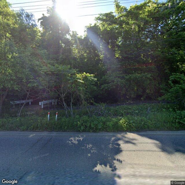
On Wednesday, May 27 at about 12:55 p.m., a witness (man in his 30s) spotted one bear (about 80 cm in body length) in the riverbed (brush) in the Ooyachi area of Inawashiro Town. The bear then crossed the Yonezawa–Inawashiro Prefectural Route from the sighting location and left into the forested mountains to the northwest.

Note: Official sources provide information in Japanese only. This description has been machine translated for your convenience.

Bear Type

Black Bear

Number of Bears

1

Provider Type

Official

Date & Time

Wednesday, May 27, 2026 at 03:55 AM

Address

Inawashiro 字清水前, Fukushima

Coordinates

37.586369, 140.124578

Sources

https://www.rfc.jp/spe/kuma/

Related Areas

Fukushima
Very High Risk

Fukushima

5,995 incidents

Lake Inawashiro
Very High Risk

Lake Inawashiro

Fukushima

1,578 incidents

Morohashi Museum of Modern Art
High Risk

Morohashi Museum of Modern Art

Fukushima

1,020 incidents

Lake Hibara
Moderate Risk

Lake Hibara

Fukushima

984 incidents

Mount Bandai
High Risk

Mount Bandai

Fukushima

791 incidents

Inawashiro
High Risk

Inawashiro

Fukushima

440 incidents

Fukushima
Very High Risk

Fukushima

5,995 incidents

Lake Inawashiro
Very High Risk

Lake Inawashiro

Fukushima

1,578 incidents

Morohashi Museum of Modern Art
High Risk

Morohashi Museum of Modern Art

Fukushima

1,020 incidents

Lake Hibara
Moderate Risk

Lake Hibara

Fukushima

984 incidents

Mount Bandai
High Risk

Mount Bandai

Fukushima

791 incidents

Inawashiro
High Risk

Inawashiro

Fukushima

440 incidents

Nearby places of interest

Attraction 908 m

Shibuya Tozanguchi

渋谷登山口

Fukushima ·42 incidents

Mountain 3.1 km

Ichi No Noyama

一ノ野山

Fukushima ·78 incidents

Mountain 3.4 km

Akahaniyama

Fukushima ·139 incidents

Mountain 4.3 km

Kushi Ke Mine

櫛ヶ峰

Fukushima ·133 incidents

Volcano 4.9 km

Mt. Bandai

Fukushima ·118 incidents

Comments (0)

0/2000

No comments yet.

Plan Your Trip Risk Map

Hiking in bear country

Safety picks and trail essentials, top-rated on Amazon and Rakuten.

Nearby Incidents

Official

Inawashiro 字清水, Fukushima

34 m

2 years ago

Official

Inawashiro 字清水, Fukushima

151 m

7 months ago

News

Inawashiro 字大谷地, Fukushima

233 m

3 weeks ago

News

Inawashiro 字大谷地, Fukushima

233 m

1 month ago

Official

Inawashiro 字下日泥, Fukushima

247 m

8 months ago

Official

Inawashiro 字清水前, Fukushima

330 m

7 months ago

Official

Inawashiro 字清水, Fukushima

342 m

7 months ago

Official

Inawashiro 字西ノ山, Fukushima

366 m

7 months ago

Official

Inawashiro 字清水, Fukushima

34 m

2 years ago

Official

Inawashiro 字清水, Fukushima

151 m

7 months ago

News

Inawashiro 字大谷地, Fukushima

233 m

3 weeks ago

News

Inawashiro 字大谷地, Fukushima

233 m

1 month ago

Official

Inawashiro 字下日泥, Fukushima

247 m

8 months ago

Official

Inawashiro 字清水前, Fukushima

330 m

7 months ago

Official

Inawashiro 字清水, Fukushima

342 m

7 months ago

Official

Inawashiro 字西ノ山, Fukushima

366 m

7 months ago

Kumamap Kumamap

Track bear incidents across Japan. Stay safe outdoors.

Explore

Map Account Areas Places of Interest Predictions Near Me Trip Planner Trip Reports Community Alerts Gear

Learn

Bear Safety Guides Blog News Data FAQ

Mobile

iOS App Android App LINE WhatsApp

Company

About Contact Report Sponsor

Legal

Privacy Terms Commercial Disclosure
© 2026 Kumamap