Kumamap Kumamap Kumamap
Map Areas Trip Planner Sponsor Alerts Report
English 日本語 한국어 简体中文 繁體中文 ไทย
Sign in
Sign in
Map Areas Trip Planner Sponsor Alerts Report
English 日本語 한국어 简体中文 繁體中文 ไทย
  1. Home
  2. Fukushima
  3. Inawashiro
  4. Kitashiobara
Incident photo 1

Official Black Bear Kitashiobara, Fukushima Jun 18, 2026, 02:20 AM

0 views
Saw one too? Report it

Location

Description

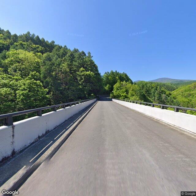
On Thursday, June 18, at around 11:20 a.m., near Nakatsugawa Bridge in the Nakatsugawa Gorge on the Bandai-Azuma Lake Line (major prefectural road connecting Fukushima and Azuma, commonly called Bandai-Azuma Lake Line) in Wakamiyaza Azumayama Ko, Inawashiro Town, a witness (woman in her 50s) traveling eastbound by vehicle on the main road sighted a bear (approximately 70 cm in body length) crossing the road from north to south. The bear left on foot into the mountain forest south of the road.

Note: Official sources provide information in Japanese only. This description has been machine translated for your convenience.

Bear Type

Black Bear

Number of Bears

1

Provider Type

Official

Date & Time

Thursday, June 18, 2026 at 02:20 AM

Address

Kitashiobara, Fukushima

Coordinates

37.672828, 140.147127

Sources

https://www.rfc.jp/spe/kuma/

Related Areas

Fukushima
Very High Risk

Fukushima

5,995 incidents

Morohashi Museum of Modern Art
High Risk

Morohashi Museum of Modern Art

Fukushima

1,020 incidents

Lake Hibara
Moderate Risk

Lake Hibara

Fukushima

984 incidents

Mount Bandai
High Risk

Mount Bandai

Fukushima

791 incidents

Mount Azuma-kofuji
Moderate Risk

Mount Azuma-kofuji

Fukushima

545 incidents

Issai kyousan
Low Risk

Issai kyousan

Fukushima

499 incidents

Inawashiro
High Risk

Inawashiro

Fukushima

440 incidents

Azuma yama
Low Risk

Azuma yama

Fukushima

166 incidents

Fukushima
Very High Risk

Fukushima

5,995 incidents

Morohashi Museum of Modern Art
High Risk

Morohashi Museum of Modern Art

Fukushima

1,020 incidents

Lake Hibara
Moderate Risk

Lake Hibara

Fukushima

984 incidents

Mount Bandai
High Risk

Mount Bandai

Fukushima

791 incidents

Mount Azuma-kofuji
Moderate Risk

Mount Azuma-kofuji

Fukushima

545 incidents

Issai kyousan
Low Risk

Issai kyousan

Fukushima

499 incidents

Inawashiro
High Risk

Inawashiro

Fukushima

440 incidents

Azuma yama
Low Risk

Azuma yama

Fukushima

166 incidents

Nearby places of interest

Attraction 41 m

Nakatsugawa Keikoku

中津川渓谷

Fukushima ·1 incidents

Cable Car 2.9 km

Grandeco Sanroku Station

Fukushima ·4 incidents

Waterfall 3.0 km

Fudou Taki

不動滝

Fukushima ·5 incidents

Mountain 3.2 km

Hakufu Yama

白布山

Fukushima ·72 incidents

Mountain 3.9 km

Saya No Kiyama

鞘ノ木山

Fukushima ·51 incidents

Comments (0)

0/2000

No comments yet.

Plan Your Trip Risk Map

Hiking in bear country

Safety picks and trail essentials, top-rated on Amazon and Rakuten.

Nearby Incidents

Official

Kitashiobara, Fukushima

2.9 km

2 years ago

Official

Kitashiobara, Fukushima

2.9 km

2 years ago

Kitashiobara, Fukushima
News

Kitashiobara, Fukushima

3.1 km

5 days ago

Official

Kitashiobara, Fukushima

3.4 km

9 months ago

Official

Inawashiro, Fukushima

3.6 km

1 year ago

Official

Inawashiro, Fukushima

3.8 km

4 years ago

Official

Inawashiro, Fukushima

3.8 km

4 years ago

Inawashiro, Fukushima
Official

Inawashiro, Fukushima

3.9 km

7 months ago

Official

Kitashiobara, Fukushima

2.9 km

2 years ago

Official

Kitashiobara, Fukushima

2.9 km

2 years ago

Kitashiobara, Fukushima
News

Kitashiobara, Fukushima

3.1 km

5 days ago

Official

Kitashiobara, Fukushima

3.4 km

9 months ago

Official

Inawashiro, Fukushima

3.6 km

1 year ago

Official

Inawashiro, Fukushima

3.8 km

4 years ago

Official

Inawashiro, Fukushima

3.8 km

4 years ago

Inawashiro, Fukushima
Official

Inawashiro, Fukushima

3.9 km

7 months ago

Kumamap Kumamap

Track bear incidents across Japan. Stay safe outdoors.

Explore

Map Account Areas Places of Interest Predictions Near Me Trip Planner Trip Reports Community Alerts Gear

Learn

Bear Safety Guides Blog News Data FAQ

Mobile

iOS App Android App LINE WhatsApp

Company

About Contact Report Sponsor

Legal

Privacy Terms Commercial Disclosure
© 2026 Kumamap