Kumamap Kumamap Kumamap
Map Areas Trip Planner Sponsor Alerts Report
English 日本語 한국어 简体中文 繁體中文 ไทย
Sign in
Sign in
Map Areas Trip Planner Sponsor Alerts Report
English 日本語 한국어 简体中文 繁體中文 ไทย
  1. Home
  2. Fukushima
  3. Fukushima
Incident photo 1

News Black Bear Fukushima, Fukushima May 9, 2026, 01:50 AM

0 views
Saw one too? Report it

Location

Description

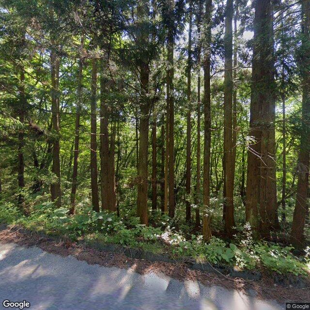
At around 10:50 a.m. on the 9th, a male driver spotted one bear (about 1.5 m long) crossing the road in Takenomori, Sahara, Fukushima City. The bear left for nearby woodland afterwards, and no damage has been reported. Police are patrolling by cruiser and coordinating with Fukushima City Hall.

Note: Official sources provide information in Japanese only. This description has been machine translated for your convenience.

Bear Type

Black Bear

Number of Bears

1

Provider Type

News

Date & Time

Saturday, May 9, 2026 at 01:50 AM

Address

Fukushima, Fukushima

Coordinates

37.709770, 140.332823

Sources

https://news.yahoo.co.jp/articles/cb9d463cf567026490083967f7...

Related Areas

Fukushima
Very High Risk

Fukushima

6,020 incidents

Fukushima Prefectural Museum of Art
High Risk

Fukushima Prefectural Museum of Art

Fukushima

1,310 incidents

Iizaka Onsen
High Risk

Iizaka Onsen

Fukushima

1,170 incidents

Fukushima
High Risk

Fukushima

Fukushima

1,129 incidents

Nihonmatsu Castle
High Risk

Nihonmatsu Castle

Fukushima

1,081 incidents

Mount Azuma-kofuji
Moderate Risk

Mount Azuma-kofuji

Fukushima

548 incidents

Mount Adatara
Moderate Risk

Mount Adatara

Fukushima

528 incidents

Issai kyousan
Low Risk

Issai kyousan

Fukushima

500 incidents

Fukushima
Very High Risk

Fukushima

6,020 incidents

Fukushima Prefectural Museum of Art
High Risk

Fukushima Prefectural Museum of Art

Fukushima

1,310 incidents

Iizaka Onsen
High Risk

Iizaka Onsen

Fukushima

1,170 incidents

Fukushima
High Risk

Fukushima

Fukushima

1,129 incidents

Nihonmatsu Castle
High Risk

Nihonmatsu Castle

Fukushima

1,081 incidents

Mount Azuma-kofuji
Moderate Risk

Mount Azuma-kofuji

Fukushima

548 incidents

Mount Adatara
Moderate Risk

Mount Adatara

Fukushima

528 incidents

Issai kyousan
Low Risk

Issai kyousan

Fukushima

500 incidents

Nearby places of interest

Waterfall 1.3 km

Omoi No Taki

思いの滝

Fukushima ·101 incidents

Theme Park 2.7 km

Shiki No Sato

四季の里

Fukushima ·175 incidents

Mountain 3.1 km

Kongou Yama

金剛山

Fukushima ·316 incidents

Mountain 3.6 km

Tsuga Mori

栂森

Fukushima ·160 incidents

Waterfall 1.3 km

Omoi No Taki

思いの滝

Fukushima ·101 incidents

Theme Park 2.7 km

Shiki No Sato

四季の里

Fukushima ·175 incidents

Mountain 3.1 km

Kongou Yama

金剛山

Fukushima ·316 incidents

Mountain 3.6 km

Tsuga Mori

栂森

Fukushima ·160 incidents

Comments (0)

0/2000

No comments yet.

Plan Your Trip Risk Map

Hiking in bear country

Safety picks and trail essentials, top-rated on Amazon and Rakuten.

Nearby Incidents

Official

Fukushima, Fukushima

37 m

1 month ago

Official

Fukushima, Fukushima

65 m

9 months ago

Official

Fukushima, Fukushima

75 m

1 year ago

Official

Fukushima, Fukushima

86 m

9 months ago

Official

Fukushima, Fukushima

173 m

10 months ago

Official

Fukushima, Fukushima

186 m

10 months ago

Official

Fukushima, Fukushima

223 m

10 months ago

Official

Fukushima, Fukushima

248 m

4 years ago

Official

Fukushima, Fukushima

37 m

1 month ago

Official

Fukushima, Fukushima

65 m

9 months ago

Official

Fukushima, Fukushima

75 m

1 year ago

Official

Fukushima, Fukushima

86 m

9 months ago

Official

Fukushima, Fukushima

173 m

10 months ago

Official

Fukushima, Fukushima

186 m

10 months ago

Official

Fukushima, Fukushima

223 m

10 months ago

Official

Fukushima, Fukushima

248 m

4 years ago

Kumamap Kumamap

Track bear incidents across Japan. Stay safe outdoors.

Explore

Map Account Areas Places of Interest Predictions Near Me Trip Planner Trip Reports Community Alerts Gear

Learn

Bear Safety Guides Blog News Data FAQ

Mobile

iOS App Android App LINE WhatsApp

Company

About Contact Report Sponsor

Legal

Privacy Terms Commercial Disclosure
© 2026 Kumamap