Kumamap Kumamap Kumamap
Map Areas Trip Planner Sponsor Alerts Report
English 日本語 한국어 简体中文 繁體中文 ไทย
Sign in
Sign in
Map Areas Trip Planner Sponsor Alerts Report
English 日本語 한국어 简体中文 繁體中文 ไทย
  1. Home
  2. Fukushima
  3. Inawashiro
  4. Inawashiro 大字壺楊
Incident photo 1

Official Black Bear Inawashiro 大字壺楊, Fukushima Jun 14, 2026, 04:43 AM

0 views
Saw one too? Report it

Location

Description

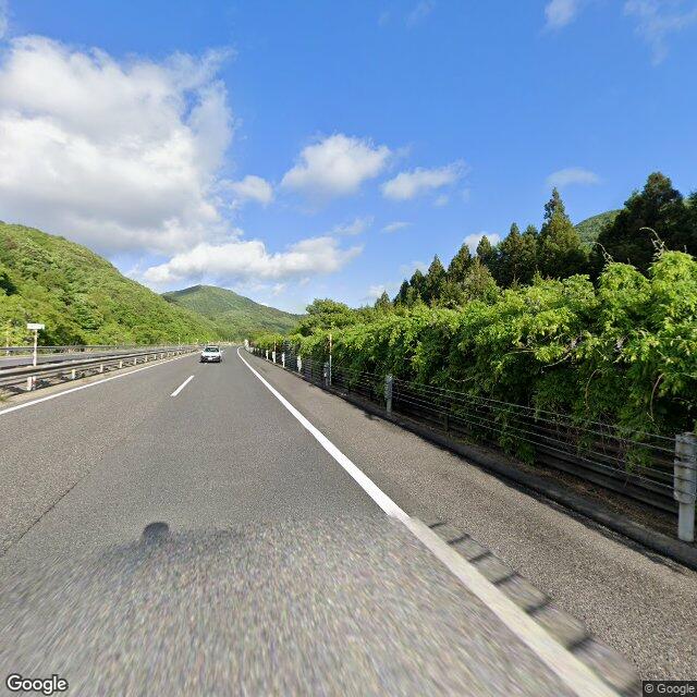
On Sunday, June 14 at approximately 1:43 p.m., near the 90.9 km post on the downhill lane of the Ban-etsu Expressway by 1684 Saka-ya, Tsuboyō, Inawashiro Town, a passenger car driven by a man in his 80s, while traveling in the first lane of the downhill direction, collided with a bear cub (about 50 cm in body length) that crossed from the right to the left side of the travel direction. The driver and passenger of the vehicle were not injured. The bear left the scene of the traffic accident.

Note: Official sources provide information in Japanese only. This description has been machine translated for your convenience.

Bear Type

Black Bear

Number of Bears

1

Provider Type

Official

Date & Time

Sunday, June 14, 2026 at 04:43 AM

Address

Inawashiro 大字壺楊, Fukushima

Coordinates

37.505074, 140.169865

Sources

https://www.rfc.jp/spe/kuma/

Related Areas

Fukushima
Very High Risk

Fukushima

5,892 incidents

Lake Inawashiro
Very High Risk

Lake Inawashiro

Fukushima

1,547 incidents

Morohashi Museum of Modern Art
Moderate Risk

Morohashi Museum of Modern Art

Fukushima

999 incidents

Inawashiro
Moderate Risk

Inawashiro

Fukushima

426 incidents

Fukushima
Very High Risk

Fukushima

5,892 incidents

Lake Inawashiro
Very High Risk

Lake Inawashiro

Fukushima

1,547 incidents

Morohashi Museum of Modern Art
Moderate Risk

Morohashi Museum of Modern Art

Fukushima

999 incidents

Inawashiro
Moderate Risk

Inawashiro

Fukushima

426 incidents

Nearby places of interest

Mountain 963 m

San Fuzan

酸釜山

Fukushima ·99 incidents

Mountain 1.2 km

Narisawa Yama

成沢山

Fukushima ·114 incidents

Ruins 1.3 km

Youji Ichiri Tsuka

楊枝一里塚

Fukushima ·4 incidents

Mountain 1.8 km

Kurate Yama

鞍手山

Fukushima ·104 incidents

Mountain 1.8 km

Kyuu Yori Yama

九寄山

Fukushima ·113 incidents

Mountain 1.9 km

Kamakura Yama

鎌倉山

Fukushima ·95 incidents

Mountain 2.0 km

Mizunashi Yama

水無山

Fukushima ·118 incidents

Train Station 2.0 km

Joko

Fukushima ·31 incidents

Comments (0)

0/2000

No comments yet.

Plan Your Trip Risk Map

Hiking in bear country

Safety picks and trail essentials, top-rated on Amazon and Rakuten.

Nearby Incidents

News

Inawashiro 大字壺楊, Fukushima

196 m

1 week ago

Official

Inawashiro 大字壺楊, Fukushima

257 m

1 year ago

Official

Inawashiro 大字壺楊, Fukushima

665 m

11 months ago

Official

Inawashiro 大字関都, Fukushima

1.1 km

0 years ago

Official

Inawashiro 大字関都, Fukushima

1.4 km

11 months ago

Inawashiro 大字関都, Fukushima
Official

Inawashiro 大字関都, Fukushima

1.6 km

7 months ago

Official

Inawashiro 大字壺楊, Fukushima

1.8 km

1 year ago

Official

Inawashiro 大字壺楊, Fukushima

1.8 km

1 year ago

Kumamap Kumamap

Track bear incidents across Japan. Stay safe outdoors.

Explore

Map Account Areas Places of Interest Predictions Near Me Trip Planner Trip Reports Community Alerts Gear

Learn

Bear Safety Guides Blog News Data FAQ

Mobile

iOS App Android App LINE WhatsApp

Company

About Contact Report Sponsor

Legal

Privacy Terms Commercial Disclosure
© 2026 Kumamap