Kumamap Kumamap Kumamap
Map Areas Trip Planner Sponsor Alerts Report
English 日本語 한국어 简体中文 繁體中文 ไทย
Sign in
Sign in
Map Areas Trip Planner Sponsor Alerts Report
English 日本語 한국어 简体中文 繁體中文 ไทย
  1. Home
  2. Fukushima
  3. Soma
  4. Soma Akagi
Incident photo 1

Official Black Bear Soma Akagi, Fukushima Jun 30, 2026

0 views
Saw one too? Report it

Location

Description

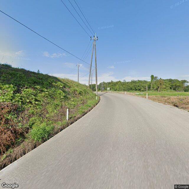
On Tuesday, June 30 at around 9:00 a.m., in Akagi Ichiridan area of Soma City, on a municipal road, a man in his 70s witnessed one bear (about 50 cm in body length) crossing the road from north to south while he was riding a motorcycle.

Note: Official sources provide information in Japanese only. This description has been machine translated for your convenience.

Bear Type

Black Bear

Number of Bears

1

Provider Type

Official

Date & Time

Tuesday, June 30, 2026

Address

Soma Akagi, Fukushima

Coordinates

37.753057, 140.951888

Sources

https://www.rfc.jp/spe/kuma/

Related Areas

Fukushima
Very High Risk

Fukushima

6,348 incidents

Port of Sōma
Low Risk

Port of Sōma

Fukushima

125 incidents

Soma
Low Risk

Soma

Fukushima

61 incidents

Fukushima
Very High Risk

Fukushima

6,348 incidents

Port of Sōma
Low Risk

Port of Sōma

Fukushima

125 incidents

Soma
Low Risk

Soma

Fukushima

61 incidents

Nearby places of interest

Attraction 908 m

Souma Shiyakusho Michi No Eki Souma Taiken Jisshuu Kan

相馬市役所 道の駅そうま体験実習館

Fukushima ·4 incidents

Train Station 1.5 km

Nittaki

Fukushima ·11 incidents

Attraction 908 m

Souma Shiyakusho Michi No Eki Souma Taiken Jisshuu Kan

相馬市役所 道の駅そうま体験実習館

Fukushima ·4 incidents

Train Station 1.5 km

Nittaki

Fukushima ·11 incidents

Comments (0)

0/2000

No comments yet.

Plan Your Trip Risk Map

Hiking in bear country

Safety picks and trail essentials, top-rated on Amazon and Rakuten.

Nearby Incidents

Official

Soma Akagi, Fukushima

457 m

1 year ago

Official

Soma Akagi, Fukushima

645 m

1 year ago

Official

Soma Akagi, Fukushima

2.2 km

1 year ago

Official

Minamisoma 鹿島区角川原, Fukushima

2.3 km

1 year ago

Official

Soma Tachiya, Fukushima

2.7 km

1 year ago

News

Shimotakamatsu, Tsubata, Soma City, Fukushima

3.1 km

6 months ago

Official

Soma Tomizawa, Fukushima

3.1 km

1 month ago

Official

Soma Tomizawa, Fukushima

3.2 km

1 year ago

Official

Soma Akagi, Fukushima

457 m

1 year ago

Official

Soma Akagi, Fukushima

645 m

1 year ago

Official

Soma Akagi, Fukushima

2.2 km

1 year ago

Official

Minamisoma 鹿島区角川原, Fukushima

2.3 km

1 year ago

Official

Soma Tachiya, Fukushima

2.7 km

1 year ago

News

Shimotakamatsu, Tsubata, Soma City, Fukushima

3.1 km

6 months ago

Official

Soma Tomizawa, Fukushima

3.1 km

1 month ago

Official

Soma Tomizawa, Fukushima

3.2 km

1 year ago

Kumamap Kumamap

Track bear incidents across Japan. Stay safe outdoors.

Explore

Map Account Areas Places of Interest Predictions Near Me Trip Planner Trip Reports Community Alerts Gear

Learn

Bear Safety Guides Blog News Data FAQ

Mobile

iOS App Android App LINE WhatsApp

Company

About Contact Report Sponsor

Legal

Privacy Terms Commercial Disclosure
© 2026 Kumamap