Kumamap Kumamap Kumamap
Map Areas Trip Planner Sponsor Alerts Report
English 日本語 한국어 简体中文 繁體中文 ไทย
Sign in
Sign in
Map Areas Trip Planner Sponsor Alerts Report
English 日本語 한국어 简体中文 繁體中文 ไทย
  1. Home
  2. Fukushima
  3. Inawashiro
  4. Inawashiro 字松峯

Official Black Bear Inawashiro 字松峯, Fukushima Sep 14, 2024, 01:40 PM

0 views
Saw one too? Report it

Location

Description

No description provided

Bear Type

Black Bear

Number of Bears

1

Provider Type

Official

Date & Time

Saturday, September 14, 2024 at 01:40 PM

Address

Inawashiro 字松峯, Fukushima

Coordinates

37.605375, 140.074225

Sources

https://www.pref.fukushima.lg.jp/uploaded/life/849259_247325...

Related Areas

Fukushima
Very High Risk

Fukushima

5,995 incidents

Fukushima Museum
High Risk

Fukushima Museum

Fukushima

1,752 incidents

Lake Inawashiro
Very High Risk

Lake Inawashiro

Fukushima

1,578 incidents

Morohashi Museum of Modern Art
High Risk

Morohashi Museum of Modern Art

Fukushima

1,020 incidents

Lake Hibara
Moderate Risk

Lake Hibara

Fukushima

984 incidents

Mount Bandai
High Risk

Mount Bandai

Fukushima

791 incidents

Inawashiro
High Risk

Inawashiro

Fukushima

440 incidents

Fukushima
Very High Risk

Fukushima

5,995 incidents

Fukushima Museum
High Risk

Fukushima Museum

Fukushima

1,752 incidents

Lake Inawashiro
Very High Risk

Lake Inawashiro

Fukushima

1,578 incidents

Morohashi Museum of Modern Art
High Risk

Morohashi Museum of Modern Art

Fukushima

1,020 incidents

Lake Hibara
Moderate Risk

Lake Hibara

Fukushima

984 incidents

Mount Bandai
High Risk

Mount Bandai

Fukushima

791 incidents

Inawashiro
High Risk

Inawashiro

Fukushima

440 incidents

Nearby places of interest
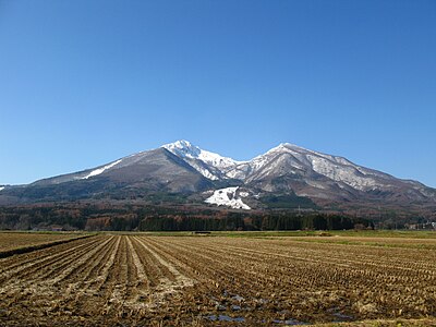
Volcano 519 m

Mt. Bandai

Fukushima ·118 incidents

Mountain 1.1 km

Kushi Ke Mine

櫛ヶ峰

Fukushima ·133 incidents

Hot Spring Source 1.5 km

Nakanoyu Ruins

Fukushima ·10 incidents

Mountain 1.6 km

Akahaniyama

Fukushima ·139 incidents

Mountain 4.1 km

Nekomagatake

Fukushima ·46 incidents

Mountain 5.0 km

Umaya Dakeyama

厩岳山

Fukushima ·63 incidents

Comments (0)

0/2000

No comments yet.

Plan Your Trip Risk Map

Hiking in bear country

Safety picks and trail essentials, top-rated on Amazon and Rakuten.

Nearby Incidents

Official

Bandai, Fukushima

1.2 km

11 months ago

Official

Kitashiobara, Fukushima

1.5 km

8 months ago

Official

Bandai, Fukushima

2.0 km

11 months ago

Official

Bandai, Fukushima

2.2 km

1 year ago

Official

Kitashiobara, Fukushima

2.3 km

10 months ago

Official

Inawashiro 字西赤道, Fukushima

2.4 km

1 month ago

Official

Bandai, Fukushima

2.6 km

4 years ago

Official

Bandai, Fukushima

2.6 km

4 years ago

Official

Bandai, Fukushima

1.2 km

11 months ago

Official

Kitashiobara, Fukushima

1.5 km

8 months ago

Official

Bandai, Fukushima

2.0 km

11 months ago

Official

Bandai, Fukushima

2.2 km

1 year ago

Official

Kitashiobara, Fukushima

2.3 km

10 months ago

Official

Inawashiro 字西赤道, Fukushima

2.4 km

1 month ago

Official

Bandai, Fukushima

2.6 km

4 years ago

Official

Bandai, Fukushima

2.6 km

4 years ago

Kumamap Kumamap

Track bear incidents across Japan. Stay safe outdoors.

Explore

Map Account Areas Places of Interest Predictions Near Me Trip Planner Trip Reports Community Alerts Gear

Learn

Bear Safety Guides Blog News Data FAQ

Mobile

iOS App Android App LINE WhatsApp

Company

About Contact Report Sponsor

Legal

Privacy Terms Commercial Disclosure
© 2026 Kumamap