Kumamap Kumamap Kumamap
Map Areas Trip Planner Sponsor Alerts Report
English 日本語 한국어 简体中文 繁體中文 ไทย
Sign in
Sign in
Map Areas Trip Planner Sponsor Alerts Report
English 日本語 한국어 简体中文 繁體中文 ไทย
  1. Home
  2. Akita
  3. Kazuno

Official Black Bear Kazuno, Akita Apr 23, 2026, 07:45 AM

0 views
Saw one too? Report it

Location

Description

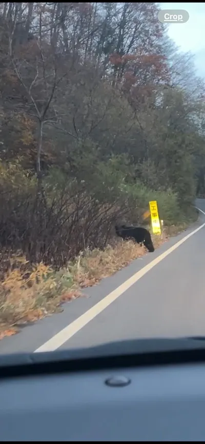
Report: Near Ōbadani-chi (about 5.5 km from Tamagawa Onsen No.1 parking lot toward Kazuno, on the mountain side) a bear on a snowy slope noticed a car, panicked, and ran uphill toward Tamagawa Onsen to escape.

Note: Official sources provide information in Japanese only. This description has been machine translated for your convenience.

Bear Type

Black Bear

Number of Bears

1

Provider Type

Official

Date & Time

Thursday, April 23, 2026 at 07:45 AM

Address

Kazuno, Akita

Coordinates

39.989919, 140.752187

Sources

https://kumadas.net

Related Areas

Akita
Very High Risk

Akita

23,155 incidents

Kazuno
Moderate Risk

Kazuno

Akita

1,585 incidents

Akita-Yakeyama
Low Risk

Akita-Yakeyama

Akita

88 incidents

Mount Hachimantai
Low Risk

Mount Hachimantai

Iwate

86 incidents

Akita
Very High Risk

Akita

23,155 incidents

Kazuno
Moderate Risk

Kazuno

Akita

1,585 incidents

Akita-Yakeyama
Low Risk

Akita-Yakeyama

Akita

88 incidents

Mount Hachimantai
Low Risk

Mount Hachimantai

Iwate

86 incidents

Nearby places of interest

Waterfall 2.0 km

So Ri Taki

曽利滝

Akita ·16 incidents

Mountain 2.1 km

San Tsu Mata Mori

三ツ又森

Akita ·16 incidents

Mountain 2.9 km

Mt. Akita-Yakeyama

Akita ·32 incidents

Mountain 3.0 km

Yokomori

横森

Akita ·37 incidents

Mountain 3.2 km

Mt. Tsugamori

Akita ·37 incidents

Mountain 3.3 km

Mt. Shibakura

Akita ·15 incidents

Mountain 3.5 km

Mikata Taka

三方高

Akita ·18 incidents

Mountain 4.0 km

Kiku Mori

椈森

Akita ·15 incidents

Comments (0)

0/2000

No comments yet.

Plan Your Trip Risk Map

Hiking in bear country

Safety picks and trail essentials, top-rated on Amazon and Rakuten.

Nearby Incidents

Official

Kazuno, Akita

212 m

3 years ago

Kazuno, Akita
Community

Kazuno, Akita

361 m

7 months ago

Official

Kazuno, Akita

405 m

3 years ago

Official

Semboku, Akita

541 m

2 years ago

Official

Semboku, Akita

2.3 km

4 years ago

Official

Kazuno, Akita

2.4 km

2 years ago

Official

Semboku Tazawako-Tamagawa, Akita

2.8 km

1 year ago

Official

Kazuno, Akita

2.9 km

2 years ago

Official

Kazuno, Akita

212 m

3 years ago

Kazuno, Akita
Community

Kazuno, Akita

361 m

7 months ago

Official

Kazuno, Akita

405 m

3 years ago

Official

Semboku, Akita

541 m

2 years ago

Official

Semboku, Akita

2.3 km

4 years ago

Official

Kazuno, Akita

2.4 km

2 years ago

Official

Semboku Tazawako-Tamagawa, Akita

2.8 km

1 year ago

Official

Kazuno, Akita

2.9 km

2 years ago

Kumamap Kumamap

Track bear incidents across Japan. Stay safe outdoors.

Explore

Map Account Areas Places of Interest Predictions Near Me Trip Planner Trip Reports Community Alerts Gear

Learn

Bear Safety Guides Blog News Data FAQ

Mobile

iOS App Android App LINE WhatsApp

Company

About Contact Report Sponsor

Legal

Privacy Terms Commercial Disclosure
© 2026 Kumamap