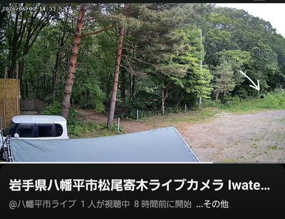
Kumamap Kumamap Kumamap
Map Areas Trip Planner Sponsor Alerts Report
English 日本語 한국어 简体中文 繁體中文 ไทย
Sign in
Sign in
Map Areas Trip Planner Sponsor Alerts Report
English 日本語 한국어 简体中文 繁體中文 ไทย
  1. Home
  2. Iwate
  3. Hachimantai
  4. Hachimantai 柏台三丁目

Official Black Bear Hachimantai 柏台三丁目, Iwate Sep 11, 2023

0 views
Saw one too? Report it

Location

Description

Attacked and injured by a bear while working at a facility.

Note: Official sources provide information in Japanese only. This description has been machine translated for your convenience.

Bear Type

Black Bear

Number of Bears

1

Provider Type

Official

Date & Time

Monday, September 11, 2023

Address

Hachimantai 柏台三丁目, Iwate

Coordinates

39.899959, 140.978927

Sources

https://www.google.com/maps/d/u/0/viewer?mid=1Rzj7qui6pXmL02...

Related Areas

Iwate
Very High Risk

Iwate

3,062 incidents

Mount Iwate
Low Risk

Mount Iwate

Iwate

60 incidents

Ou Mountains
Low Risk

Ou Mountains

Iwate

59 incidents

Hachimantai
Low Risk

Hachimantai

Iwate

49 incidents

Iwate
Very High Risk

Iwate

3,062 incidents

Mount Iwate
Low Risk

Mount Iwate

Iwate

60 incidents

Ou Mountains
Low Risk

Ou Mountains

Iwate

59 incidents

Hachimantai
Low Risk

Hachimantai

Iwate

49 incidents

Nearby places of interest

Hotel 710 m

Hachimantai Mountain Hotel

Iwate ·2 incidents

Hotel 886 m

Hachimandai royal hotel

Hachimandai Royal Hotel

Iwate ·3 incidents

Community Centre 1.3 km

Iwateken Kenmin No Mori Shinrin Fureai Gakushuu Sentaa

岩手県県民の森森林ふれあい学習センター

Iwate ·2 incidents

Mountain 4.5 km

Akakura Gaku

赤倉岳

Iwate ·1 incidents

Mountain 4.6 km

Shita Kurayama

下倉山

Iwate ·4 incidents

Mountain 4.8 km

Byoubu One

屏風尾根

Iwate ·1 incidents

Comments (0)

0/2000

No comments yet.

Plan Your Trip Risk Map

Hiking in bear country

Safety picks and trail essentials, top-rated on Amazon and Rakuten.

Nearby Incidents

Hachimantai, Iwate
Community

Hachimantai, Iwate

939 m

3 weeks ago

Official

Hachimantai, Iwate

2.3 km

7 years ago

Entrance of Iwatesan Service Area (southbound Tohoku Expressway), Hachimantai City, Iwate
News

Entrance of Iwatesan Service Area (southbound Tohoku Expressway), Hachimantai City, Iwate

6.0 km

7 months ago

Official

Hachimantai, Iwate

6.0 km

1 year ago

Official

Hachimantai, Iwate

6.1 km

2 years ago

Noda, Hachimantai, Iwate, Iwate
News

Noda, Hachimantai, Iwate, Iwate

6.6 km

7 months ago

Official

Hachimantai, Iwate

6.7 km

5 years ago

News

Matsuo Junior High School (Hachimantai), Iwate

7.8 km

7 months ago

Hachimantai, Iwate
Community

Hachimantai, Iwate

939 m

3 weeks ago

Official

Hachimantai, Iwate

2.3 km

7 years ago

Entrance of Iwatesan Service Area (southbound Tohoku Expressway), Hachimantai City, Iwate
News

Entrance of Iwatesan Service Area (southbound Tohoku Expressway), Hachimantai City, Iwate

6.0 km

7 months ago

Official

Hachimantai, Iwate

6.0 km

1 year ago

Official

Hachimantai, Iwate

6.1 km

2 years ago

Noda, Hachimantai, Iwate, Iwate
News

Noda, Hachimantai, Iwate, Iwate

6.6 km

7 months ago

Official

Hachimantai, Iwate

6.7 km

5 years ago

News

Matsuo Junior High School (Hachimantai), Iwate

7.8 km

7 months ago

Kumamap Kumamap

Track bear incidents across Japan. Stay safe outdoors.

Explore

Map Account Areas Places of Interest Predictions Near Me Trip Planner Trip Reports Community Alerts Gear

Learn

Bear Safety Guides Blog News Data FAQ

Mobile

iOS App Android App LINE WhatsApp

Company

About Contact Report Sponsor

Legal

Privacy Terms Commercial Disclosure
© 2026 Kumamap