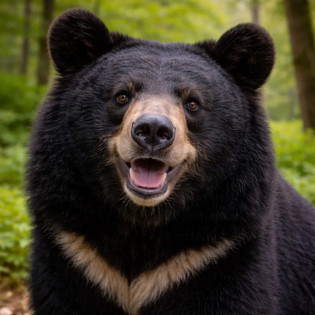
Kumamap Kumamap Kumamap
แผนที่ พื้นที่ การคาดการณ์ วางแผนการเดินทาง ชุมชน การแจ้งเตือน อุปกรณ์
English 日本語 한국어 简体中文 繁體中文 ไทย
รายงาน
รายงาน
แผนที่ พื้นที่ การคาดการณ์ วางแผนการเดินทาง ชุมชน การแจ้งเตือน อุปกรณ์
English 日本語 한국어 简体中文 繁體中文 ไทย
  1. หน้าแรก
  2. วางแผนการเดินทาง
  3. รายงานการเดินทาง
  4. เส้นทางเดินป่า JP Tower-Port of Miyako

เส้นทางเดินป่า JP Tower-Port of Miyako

ความเสี่ยงสูง · 576 km · 2 จุด · 13 เหตุการณ์ · บันทึกเมื่อ 5 พฤษภาคม 2569 · อัปเดตล่าสุด: 6ชั่วโมงที่แล้ว
0 การดู
5
เหตุการณ์ใน 7 วันที่ผ่านมา
13
เหตุการณ์ใน 30 วันที่ผ่านมา
16ชั่วโมงที่แล้ว
การปรากฏตัวล่าสุด

สรุปความปลอดภัย

เส้นทางจาก JP Tower ถึง Port of Miyako ระยะทาง 576 km ผ่านพื้นที่ โตเกียว จังหวัดอิวาเตะ จังหวัดชิบะ จังหวัดฟุกุชิมะ จังหวัดอิบะระกิ จังหวัดมิยางิ และจังหวัดไซตามะ ในช่วง 30 วันที่ผ่านมา มีรายงานหมี 13 ครั้งในรัศมี 5 กิโลเมตรจากเส้นทาง โดย 5 ครั้งเกิดขึ้นใน 7 วันล่าสุด เส้นทางนี้อยู่ในเขตที่อยู่อาศัยของหมีดำเอเชีย (พบในเกาะฮอนชูและชิโกกุ) รายงานล่าสุดเกิดขึ้น 16ชั่วโมงที่แล้ว ใกล้ Otsuchi Kirikiri, Iwate โดยจุดเกิดเหตุอยู่ห่างจากจุดเริ่มต้นประมาณ 542.2 km และห่างจากเส้นทางหลัก 2.1 km จุดที่ใกล้เส้นทางที่สุดเกิดขึ้น 6วันที่แล้ว ที่ Ishinomaki 小船越, Miyagi โดยอยู่ห่างจากจุดเริ่มต้นประมาณ 394.0 km และห่างจากเส้นทาง 283 m

ด้วยความหนาแน่นของรายงานล่าสุด ควรพิจารณาเปลี่ยนเวลาออกเดินทางหรือเลือกเส้นทางอื่น

เส้นทางของคุณ

ภาพรวมเส้นทาง

จุดเด่นตลอดเส้นทาง (24)

24 จุดในระยะ 1 กม. ผ่าน โตเกียว, จังหวัดอิวาเตะ, จังหวัดชิบะ, จังหวัดฟุกุชิมะ, จังหวัดอิบะระกิ, จังหวัดมิยางิ, จังหวัดไซตามะ

Hibiya Open-Air Concert Hall
ความเสี่ยงต่ำ

Hibiya Open-Air Concert Hall

โตเกียว

ยังไม่มีเหตุการณ์

Hibiya Park
ความเสี่ยงต่ำ

Hibiya Park

โตเกียว

ยังไม่มีเหตุการณ์

Tokyo Midtown Hibiya
ความเสี่ยงต่ำ

Tokyo Midtown Hibiya

โตเกียว

ยังไม่มีเหตุการณ์

Mizuho Bank Uchisaiwaichō Head Office Building
ความเสี่ยงต่ำ

Mizuho Bank Uchisaiwaichō Head Office Building

โตเกียว

ยังไม่มีเหตุการณ์

Kōkyogaien
ความเสี่ยงต่ำ

Kōkyogaien

โตเกียว

ยังไม่มีเหตุการณ์

Marunouchi Building
ความเสี่ยงต่ำ

Marunouchi Building

โตเกียว

ยังไม่มีเหตุการณ์

JP Tower
ความเสี่ยงต่ำ

JP Tower

โตเกียว

ยังไม่มีเหตุการณ์

Shin-Marunouchi Building
ความเสี่ยงต่ำ

Shin-Marunouchi Building

โตเกียว

ยังไม่มีเหตุการณ์

Hibiya Open-Air Concert Hall
ความเสี่ยงต่ำ

Hibiya Open-Air Concert Hall

โตเกียว

ยังไม่มีเหตุการณ์

Hibiya Park
ความเสี่ยงต่ำ

Hibiya Park

โตเกียว

ยังไม่มีเหตุการณ์

Tokyo Midtown Hibiya
ความเสี่ยงต่ำ

Tokyo Midtown Hibiya

โตเกียว

ยังไม่มีเหตุการณ์

Mizuho Bank Uchisaiwaichō Head Office Building
ความเสี่ยงต่ำ

Mizuho Bank Uchisaiwaichō Head Office Building

โตเกียว

ยังไม่มีเหตุการณ์

Kōkyogaien
ความเสี่ยงต่ำ

Kōkyogaien

โตเกียว

ยังไม่มีเหตุการณ์

Marunouchi Building
ความเสี่ยงต่ำ

Marunouchi Building

โตเกียว

ยังไม่มีเหตุการณ์

JP Tower
ความเสี่ยงต่ำ

JP Tower

โตเกียว

ยังไม่มีเหตุการณ์

Shin-Marunouchi Building
ความเสี่ยงต่ำ

Shin-Marunouchi Building

โตเกียว

ยังไม่มีเหตุการณ์

รายละเอียดแต่ละช่วง

|
S
JP Tower, โตเกียว
ความเสี่ยงสูง 576 km ในระยะ 5 กม. 13 เหตุการณ์
Otsuchi Kirikiri, Iwate

At the contained large forest fire in Otsuchi Town, firefighters resumed extinguishing a heat source on May 7, 2026, located on the seaward side of the town road Rias Scenic Line in the Kirikiri district; personnel entered the mountain with members of the hunters' association around 09:45, with an infrared camera-equipped helicopter providing aerial backup. A helicopter survey on the 6th had confirmed at least three bears, so ground operations were suspended on the 6th and aerial firefighting was used.

Otsuchi Kirikiri, Iwate

ข่าว ·16ชั่วโมงที่แล้ว
Soma Nakamura, Fukushima

A bear sighting was reported in Soma City, Fukushima Prefecture (see the article body for location details).

Soma Nakamura, Fukushima

ข่าว ·2วันที่แล้ว
Iwanuma Honchō, Miyagi

At around 03:40 on the 5th, a resident spotted a single bear heading east on a road in Kuwabara 1-chome, Iwanuma City, Miyagi Prefecture. According to the prefectural police, the bear was about 1 meter long; officers patrolled the area but the animal had already left.

Iwanuma Honchō, Miyagi

ข่าว ·2วันที่แล้ว
แสดง 10 เพิ่มเติม
Soma Nakamura, Fukushima

On May 5, 2026, reports of sightings and footprints of bears or bear-like animals were reported repeatedly across Fukushima Prefecture, including on the Hama Kaido in Minamisoma City. According to police stations, some reports included descriptions of body length, but details are unclear.

Soma Nakamura, Fukushima

ข่าว ·3วันที่แล้ว
Ishinomaki 小船越, Miyagi

On May 2 a bear-like animal was sighted on the mountain designated as an evacuation site, so Ishinomaki Otayachi Elementary School postponed the tsunami evacuation drill for children that had been scheduled for May 7, when they would walk to the mountain.

Ishinomaki 小船越, Miyagi

ข่าว ·6วันที่แล้ว

On the morning of April 23, 2026, one bear was sighted in Higashimatsushima City, Miyagi Prefecture, and reported to the city office. Around 10:00 a.m., a person driving near Joge-tsutsumi in Higashimatsushima saw a bear crossing a national route north–south and reported it.

Higashimatsushima Jogetsutsumi, Miyagi

ข่าว ·2สัปดาห์ที่แล้ว
Iwaki, Fukushima

At around 05:50 on April 20, a driver observed an animal believed to be a bear about 1 meter long crossing a municipal road in Taki Kamisunaji, Tono-cho, Iwaki City, moving from the forest on the west side to the forest on the east side. No human injuries were reported, and police have urged local residents to remain vigilant.

Iwaki, Fukushima

ข่าว ·2สัปดาห์ที่แล้ว
Tome 中田町浅水, Miyagi

At around 17:40 on the 15th, a patrolling police officer in a fallow field in Asamizu, Nakatacho, Tome City, spotted a bear about 1 meter long that moved away in the opposite direction from a nearby residential area. No damage has been reported, and the police continue to warn residents to be cautious.

Tome 中田町浅水, Miyagi

ข่าว ·3สัปดาห์ที่แล้ว

On the 14th in Miyagi Prefecture, three bears about 1 meter long were sighted: in Ishinomaki City Hirobuchi (around 19:10), Osaki City Furukawa Fukunuma 2-chome (around 21:50), and Sendai City Aoba-ku Futabagaoka 2-chome (around 22:40). No injuries have been reported at any of the locations, and police have stepped up patrols and warned residents to be cautious.

Ishinomaki 広渕, Miyagi

ข่าว ·3สัปดาห์ที่แล้ว
Shinchi Suginome, Fukushima

Around 10:30 on April 12, a man in his 30s hiking Mount Karō (Karōzan) in Sugime, Shinchi Town, Fukushima Prefecture, spotted one bear about 1.5 meters long. No damage has been reported in the area, and police are urging hikers to be cautious.

Shinchi Suginome, Fukushima

ข่าว ·3สัปดาห์ที่แล้ว
Shinchi Suginome, Fukushima

On the morning of April 12, 2026, a male hiker sighted one bear about 150 cm long near the trail of Mount Karō (鹿狼山) in Shinchi Town. On April 14 the town posted warning signs at the trailhead urging hikers to take precautions such as traveling in groups, carrying bells or radios, avoiding early-morning and evening hikes, and taking their trash home.

Shinchi Suginome, Fukushima

ข่าว ·3สัปดาห์ที่แล้ว
Ofunato Ikawacho, Iwate

At around 15:50 on April 9, 2026, a single adult bear about 1 meter long was sighted in Ritsunecho, Ofunato City, Iwate Prefecture (near the Ritsune police post). The bear headed west toward the mountains; as of 17:00 no damage to people or buildings had been confirmed and the police have urged nearby residents to be cautious.

Ofunato Ikawacho, Iwate

ข่าว ·1 เดือนที่แล้ว

At around 14:45 on the 9th, a man passing by spotted one bear walking toward the northern woodland at the Okumatsushima Park mallet golf course in Nobiru, Higashimatsushima. Police said the bear was about 1 meter long; it left the scene and no damage was reported.

Higashimatsushima Nobiru, Miyagi

ข่าว ·1 เดือนที่แล้ว
G
Port of Miyako, จังหวัดอิวาเตะ
ระยะทางทั้งหมด: 576 km

หมีเคลื่อนไหวมากที่สุดเมื่อไหร่?

กิจกรรมพีคที่ 9:00 มี 2 เหตุการณ์

หมีดำเอเชียบนเส้นทางของคุณ

หมีดำเอเชีย

หมีดำเอเชีย

Ursus thibetanus japonicus

แหล่งที่อยู่
ฮอนชู, ชิโกกุ
น้ำหนัก
80–120 กก.
ช่วงเวลาที่กระตือรือร้น
รุ่งสาง / ค่ำ

อยู่ร่วมกันอย่างปลอดภัย

  • ·ส่งเสียงขณะเดิน; พกสเปรย์ไล่หมี
  • ·หากถูกพุ่งใส่ ยืนนิ่งและใช้สเปรย์
  • ·หากสัมผัส: ขัดขืนอย่างหนักแน่น หมีจะถอยเมื่อพบการต่อต้าน
  • ·อย่าปีนต้นไม้ หมีปีนเก่งกว่าคุณ

รายการตรวจสอบความปลอดภัย

อุปกรณ์เดินป่าในญี่ปุ่น

อุปกรณ์รับมือหมีและเดินป่า คะแนนสูงบน Amazon และ Rakuten

เบอร์ติดต่อฉุกเฉิน

110
ตำรวจ
119
ดับเพลิง/รถพยาบาล

สำหรับการกู้ภัยบนภูเขา โทร 110 (ตำรวจ) พวกเขาจะประสานงานกับทีมกู้ภัยท้องถิ่น

รายงานการเดินทาง - ทะเลสาบบิวะ
แผนที่วิเคราะห์ความเสี่ยงหมีแสดงเส้นทางพร้อมระดับความปลอดภัย
ความเสี่ยงสูงมาก
ความเสี่ยงสูง
ความเสี่ยงปานกลาง
ความเสี่ยงต่ำ

ชอบไหม? วางแผนเส้นทางของคุณเองได้เลย

วาดเส้นทางใดก็ได้ในญี่ปุ่น แล้วรับรายงานความปลอดภัยจากหมีในแบบเดียวกัน ปรับให้เข้ากับการเดินทางจริงของคุณ

  • ฐานข้อมูลเหตุการณ์เดียวกับที่ใช้ในรายงานนี้
  • การคาดการณ์ความเสี่ยงเฉพาะเส้นทางของคุณ
  • ฟรี ทันที ไม่ต้องสมัคร
วางแผนเส้นทางของฉัน ดูเส้นทางอื่นเพิ่มเติม

ความคิดเห็น (0)

0/2000

ยังไม่มีความคิดเห็น

คำถามที่พบบ่อยเกี่ยวกับเส้นทางนี้

มีรายงานหมีบนเส้นทางนี้กี่ครั้ง?

ในช่วง 30 วันที่ผ่านมา มีรายงานหมี 13 ครั้งในรัศมี 5 กิโลเมตรจากเส้นทางนี้ โดย 5 ครั้งเกิดขึ้นใน 7 วันล่าสุด เส้นทางนี้อยู่ในเขตที่อยู่อาศัยของหมีดำเอเชีย (พบในเกาะฮอนชูและชิโกกุ)

รายงานหมีครั้งล่าสุดใกล้เส้นทางนี้คือเมื่อใดและที่ไหน?

รายงานล่าสุดเกิดขึ้น 16ชั่วโมงที่แล้ว ใกล้ Otsuchi Kirikiri, Iwate โดยจุดเกิดเหตุอยู่ห่างจากจุดเริ่มต้นประมาณ 542.2 km และห่างจากเส้นทางหลัก 2.1 km

หมีออกหากินมากที่สุดในช่วงเวลาใดในพื้นที่นี้?

รายงานล่าสุดบนเส้นทางนี้กระจุกตัวประมาณ 9:00 หมีมักจะออกหากินมากในช่วงรุ่งสางและพลบค่ำ

เส้นทางนี้ปลอดภัยหรือไม่ในตอนนี้?

เส้นทางจาก JP Tower ถึง Port of Miyako ระยะทาง 576 km ผ่านพื้นที่ โตเกียว จังหวัดอิวาเตะ จังหวัดชิบะ จังหวัดฟุกุชิมะ จังหวัดอิบะระกิ จังหวัดมิยางิ และจังหวัดไซตามะ ในช่วง 30 วันที่ผ่านมา มีรายงานหมี 13 ครั้งในรัศมี 5 กิโลเมตรจากเส้นทาง โดย 5 ครั้งเกิดขึ้นใน 7 วันล่าสุด เส้นทางนี้อยู่ในเขตที่อยู่อาศัยของหมีดำเอเชีย (พบในเกาะฮอนชูและชิโกกุ) รายงานล่าสุดเกิดขึ้น 16ชั่วโมงที่แล้ว ใกล้ Otsuchi Kirikiri, Iwate โดยจุดเกิดเหตุอยู่ห่างจากจุดเริ่มต้นประมาณ 542.2 km และห่างจากเส้นทางหลัก 2.1 km จุดที่ใกล้เส้นทางที่สุดเกิดขึ้น 6วันที่แล้ว ที่ Ishinomaki 小船越, Miyagi โดยอยู่ห่างจากจุดเริ่มต้นประมาณ 394.0 km และห่างจากเส้นทาง 283 m ด้วยความหนาแน่นของรายงานล่าสุด ควรพิจารณาเปลี่ยนเวลาออกเดินทางหรือเลือกเส้นทางอื่น

กลับไปยังรายงานการเดินทาง
Kumamap Kumamap

ติดตามเหตุการณ์หมีทั่วญี่ปุ่น ปลอดภัยในกิจกรรมกลางแจ้ง

สำรวจ

แผนที่ พื้นที่ การคาดการณ์ ใกล้ฉัน วางแผนการเดินทาง รายงานการเดินทาง ชุมชน การแจ้งเตือน อุปกรณ์

เรียนรู้

คู่มือความปลอดภัยจากหมี บล็อก ข่าว ข้อมูล คำถามที่พบบ่อย

มือถือ

แอป iOS แอป Android LINE WhatsApp

บริษัท

เกี่ยวกับ ติดต่อ รายงาน โฆษณา

กฎหมาย

ความเป็นส่วนตัว เงื่อนไข การเปิดเผยข้อมูลเชิงพาณิชย์

พาร์ทเนอร์

mistweaverco.com
© 2026 Kumamap